Much better odds for surf as a strong SE surge builds up the coast Fri, with a broad SE fetch in the Coral Sea over next weekend and into early next week. That should see rideable surf develop Fri and hold in the fun-sized range into the weekend and potentially early week after.
Primary tabs
/reports/forecaster-notes/central-queensland/2023/10/20/small-over-the-weekend-hope-the-horizon-0
freeride76
Friday, 20 October 2023
/reports/forecaster-notes/central-queensland/2023/10/20/small-over-the-weekend-hope-the-horizon
freeride76
Friday, 20 October 2023
Much better odds for surf as a strong SE surge builds up the coast Fri, with a broad SE fetch in the Coral Sea over next weekend and into early next week. That should see rideable surf develop Fri and hold in the fun-sized range into the weekend and potentially early week after.
/reports/forecaster-notes/central-queensland/2023/10/18/just-rideable-surf-easing-quickly-the-weekend
freeride76
Wednesday, 18 October 2023
The synoptic set-up looks quite unseasonal at the moment with a 1031 hPa high drifting over NSW and a 1007 hPa low slow moving in the Tasman west of the North Island. The SE surge from this high has generated some small, scrappy surf. Get in quickly for this swell, we’ll see some more small surf tomorrow then easing swells for Fri and back to flat for the weekend.

/reports/forecaster-notes/central-queensland/2023/10/16/same-outlook-tiny
freeride76
Monday, 16 October 2023
A strong front and embedded trough of low pressure are currently located just off the Gippsland Coast, expected to move NE into the Tasman and driving a strong/ near gale force S’ly flow up the NSW Coast today, reaching the QLD in the wee hours of Tuesday. We may see a small increase in SE swell as the S-SE surge reaches CQ coastline on later Tues. Nothing major, but we may see surf bump up a touch into the 1-1.5ft range Tues a’noon, holding at that size or 1-2ft Wed.
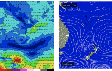
/reports/forecaster-notes/central-queensland/2023/10/11/nothing-much-the-radar
freeride76
Wednesday, 11 October 2023
Weak winds in the Coral Sea and approaching fronts have shut down swell productions for CQ. As a result we're looking at tiny/flat surf over the weekend with onshore winds. This continues into early next week.
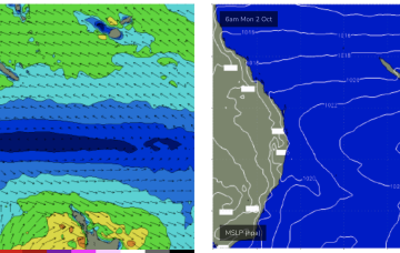
/reports/forecaster-notes/central-queensland/2023/09/29/keep-the-boards-handy-another-round-small-fun
freeride76
Friday, 29 September 2023
Mon should be the low point, possibly running into Tues before we see a modest rebuild in new E’ly tradewind swell as tradewinds reestablish across the South and Eastern Coral Seas.

/reports/forecaster-notes/central-queensland/2023/09/27/just-rideable-the-weekend-small-boost-likely
freeride76
Wednesday, 27 September 2023
High cells are now tending to move NE as they enter the Tasman, with just enough tradewind flow through the Coral Sea to maintain a small drumbeat of surf in CQ, favouring open breaks on the Burnett Coast.
/reports/forecaster-notes/central-queensland/2023/09/25/rideable-waves-most-days-fun-spring-continues
freeride76
Monday, 25 September 2023
The high pressure belt is behaving in typical spring fashion- tracking NE as it enters the Tasman with the SE surge dissipating and swells easing from that source. Combined with some swell from a tradewind band feeding into a long trough we’ll see small swells this week, just rideable on low tides. New high pressure moving into the Tasman rebuilds the tradewind fetch late this week with small swells bumping up a notch on the weekend.
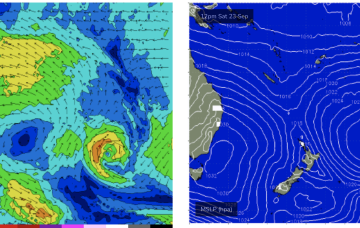
/reports/forecaster-notes/central-queensland/2023/09/22/fun-waves-over-the-weekend-and-early-next
freeride76
Friday, 22 September 2023
High pressure has bought a strong SE surge now establishing a strong ridge up the CQ coast and a developing SE swell. That will see see fun waves develop overnight and hold through the weekend under mod/fresh SE winds.
/reports/forecaster-notes/central-queensland/2023/09/20/waiting-the-next-se-surge-deliver-more-waves
freeride76
Wednesday, 20 September 2023
High pressure is now close to New Zealand, with an advancing trough and cold front bringing a fresh S’ly change, expected to generate a strong SE surge up the sub-tropical coast as a new high moves into the Bight and strengthens. Once the new high high moves into the Tasman over the weekend it’ll set up a blocking pattern with constant SE-E/SE winds and plenty of fun sized surf.