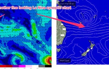
Breaks with exposed access to the east will see better quality E swell through Thurs and Fri from TC Cody as it drifts south from Fiji towards the North Island.
Primary tabs
/reports/forecaster-notes/central-queensland/2022/01/12/mix-e-swells-maintains-fun-surf-exposed
freeride76
Wednesday, 12 January 2022
/reports/forecaster-notes/central-queensland/2022/01/10/rideable-surf-week-better-quality-pulses
freeride76
Monday, 10 January 2022
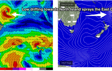
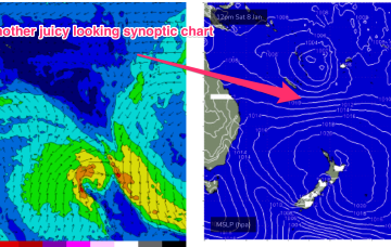
Fri should see better quality E swell coming around the corner from Fraser Island, generated by a long fetch of E’ly winds through the South Pacific as a tropical low drifts down towards New Zealand
/reports/forecaster-notes/central-queensland/2022/01/07/periods-small-rideable-waves-next-week
freeride76
Friday, 7 January 2022
This sets up a good coverage of tradewinds through the Southern and Central Coral Sea, extending out to New Caledonia, where a tropical low located between Fiji and Vanuatu is located.
/reports/forecaster-notes/central-queensland/2022/01/05/rideable-waves-likely-return-next-week
freeride76
Wednesday, 5 January 2022
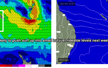
Next week looks to have better prospects although we won’t have the surf potential we saw from TC Seth.
/reports/forecaster-notes/central-queensland/2022/01/03/more-potential-surf-the-way-after-period-tiny
freeride76
Monday, 3 January 2022
A long cradling fetch of E/SE Tradewinds forms in that general region, which is likely to be a more reliable swell producer, especially for the more exposed breaks on the Burnett coast.
/reports/forecaster-notes/central-queensland/2021/12/30/strong-hybrid-low-tracking-down-qld-coast
freeride76
Friday, 31 December 2021
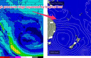
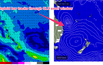
A hybrid tropical low is now located E/SE of Cairns and moving SE, energising a long, broad fetch of SE winds as it squeezes onto a supporting high pressure system in the Tasman Sea
/reports/forecaster-notes/central-queensland/2021/12/29/waves-end-the-year-tropical-low-steams-down
freeride76
Wednesday, 29 December 2021
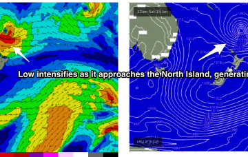
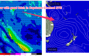
Friday looks to be the best day from Yeppoon southwards. The low will be intensifying as it drifts level with the Capricorn Coast
/reports/forecaster-notes/central-queensland/2021/12/27/waves-the-way-mid-week-great-potential-the
freeride76
Monday, 27 December 2021
The high pressure surge sees SE winds developing into the 20-25 knot range north of Fraser into the Capricorn channel during Wed, strengthening during the day.

/reports/forecaster-notes/central-queensland/2021/12/24/lots-potential-next-week-coral-sea-comes-life
freeride76
Friday, 24 December 2021
Next week offers a major pattern change for the QLD coast as a dominant high pressure system drifting E of Tasmania sets up a strong high pressure ridge along the coast.