The Tasman low of sub-tropical origins which has sprayed the East Coast with swell is now just north of the North Island, with some swell generating winds still active to the west of the North Island, although quite limited in length. It’s deepened and is hammering the North Island.
Primary tabs
/reports/forecaster-notes/sydney-hunter-illawarra/2023/10/30/enough-swell-sources-stay-busy-week
freeride76
Monday, 30 October 2023
/reports/forecaster-notes/sydney-hunter-illawarra/2023/10/27/plenty-swell-although-down-notch
freeride76
Friday, 27 October 2023
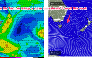
We’ve still got the building blocks in place for large swells across most of the Eastern Seaboard, with a large high , powerful frontal system, and deepening trough (still expected to form a surface low) in the Northern Tasman currently in play.
/reports/forecaster-notes/sydney-hunter-illawarra/2023/10/25/strong-swell-bombardment-ahead-powerful
freeride76
Wednesday, 25 October 2023
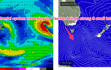
Spectacular charts more characteristic of late Summer/Autumn with a Cat 5 TC in the South Pacific bearing down on Vanuatu, and a powerful frontal intrusion poised to enter the Tasman Sea backed by a monster high in the Bight.
/reports/forecaster-notes/sydney-hunter-illawarra/2023/10/23/stacked-forecast-lots-wind-and-swell
freeride76
Monday, 23 October 2023
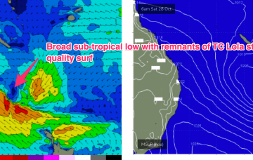
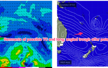
Late in the week, a combination of inland upper trough and a long angled trough extending from TC Lola remnants is expected to form a powerful surface low off the sub-tropical NSW Coast (likely between Lord Howe and Norfolk Is). As modelled, gales will produce a large E’ly quadrant swell event, with maximum size in Northern NSW, grading smaller into temperate NSW. A secondary October surprise that looks to be a major swell producer
/reports/forecaster-notes/sydney-hunter-illawarra/2023/10/20/plenty-options-over-the-weekend-another
freeride76
Friday, 20 October 2023
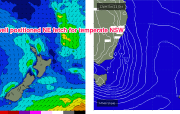
No great change to the weekend f/cast. An approaching complex trough, front and low complex will see freshening N/NE-NE winds through Sat with only a brief period of light NW winds inshore early.
/reports/forecaster-notes/sydney-hunter-illawarra/2023/10/18/active-tasman-sea-sees-swell-around-the
freeride76
Wednesday, 18 October 2023
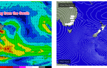
The synoptic set-up looks quite unseasonal at the moment with a 1031 hPa high drifting over NSW and a 1007 hPa low slow moving in the Tasman west of the North Island. Current ASCAT (satellite windspeed) passes show broad fetch of mostly strong S-S/SE winds with some embedded low end gales reasonably well aimed for East coast swell production.
/reports/forecaster-notes/sydney-hunter-illawarra/2023/10/16/plenty-s-swell-short-term-cleaner-better
freeride76
Monday, 16 October 2023
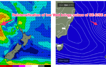
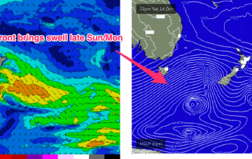
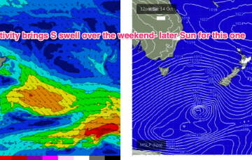
A strong front and embedded trough of low pressure are currently located just off the Gippsland Coast, expected too move NE into the Tasman and driving a strong/ near gale force S’ly flow up the NSW Coast today, reaching the QLD in the wee hours of Tuesday. There’ll be an initial burst of S swell associated with the proximate fetch, with some better quality SE-E/SE swell from a secondary intensification of the low as it becomes slow moving near New Zealand.
/reports/forecaster-notes/sydney-hunter-illawarra/2023/10/13/plenty-s-swell-over-the-weekend-windy
freeride76
Friday, 13 October 2023
We’ve got more clarity on the situation next week now as a lingering trough line from the NSW South Coast down to Gippsland is expected to deepen in response to a front and form a surface low in the Tasman Sea, likely later Mon.
/reports/forecaster-notes/sydney-hunter-illawarra/2023/10/11/more-swells-the-s-some-potential-next
freeride76
Wednesday, 11 October 2023
Moderate strength high pressure (1025 hPa) is drifting NE into the Tasman with a strong polar storm well SW of NZ exiting the swell window. That should see a settled short term before another complex trough and frontal system pushes north along the coast tomorrow with a stiff SW-S change. More rapid wind changes into and over the weekend under a very mobile, troughy pattern with some potential next week for a surface low to form in one of the trough lines.
/reports/forecaster-notes/sydney-hunter-illawarra/2023/10/09/coupla-south-swells-week-mixed
thermalben
Monday, 9 October 2023
The early arrival of today’s south swell means the short term schedule has been brought forward