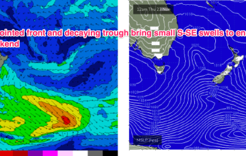
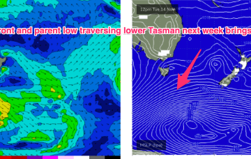
It’s a weak synoptic pattern with no major swell sources- a passing front weakens as it traverses the Tasman, leaving an off-axis fetch parallel with New Zealand. There should be enough minor swell sources of no real quality to stay wet through the short term.
Primary tabs
/reports/forecaster-notes/sydney-hunter-illawarra/2023/11/21/mix-local-and-flukey-swell-sources
freeride76
Wednesday, 22 November 2023
/reports/forecaster-notes/sydney-hunter-illawarra/2023/11/19/troughy-pattern-few-small-swell-sources
freeride76
Monday, 20 November 2023
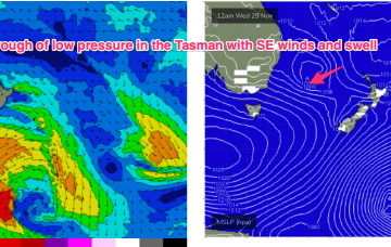
The troughy pattern remains installed into the medium term so we’re still keeping an eye out for short range features which could supply local swell sources.
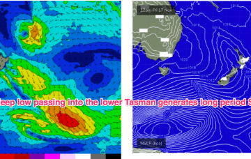
/reports/forecaster-notes/sydney-hunter-illawarra/2023/11/17/active-outlook-continues-more-long
freeride76
Friday, 17 November 2023
Strong, long period S’ly groundswell should be peaking Mon morning, before an easing trend through the day.
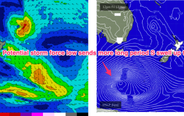
/reports/forecaster-notes/sydney-hunter-illawarra/2023/11/15/more-long-period-s-swell-if-youre-lucky
freeride76
Wednesday, 15 November 2023
Another powerful low tracking into the Far Southern Tasman- this time at potential storm force- sends more uncommonly long period S swell up the NSW Coast (although better aimed up the Tasman Sea pipe towards Fiji). With swell periods potentially in the 19-20 second band there’ll be some real juice in the swell.
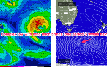
/reports/forecaster-notes/sydney-hunter-illawarra/2023/11/13/tricky-troughy-winds-some-long-period
freeride76
Monday, 13 November 2023
Another powerful low tracking into the Far Southern Tasman- this time at potential storm force- sends more uncommonly long period S swell up the NSW Coast (although better aimed up the Tasman Sea pipe towards Fiji).
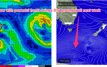
/reports/forecaster-notes/sydney-hunter-illawarra/2023/11/10/ne-wind-swells-get-replaced-sly-swells
freeride76
Friday, 10 November 2023
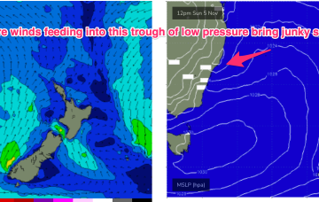
Much stronger frontal activity in the Far Southern Tasman tied to a deep, slow moving low will provide long period S’ly groundswell pulses next week, although winds are looking very tricky around a weak, troughy pattern.
/reports/forecaster-notes/sydney-hunter-illawarra/2023/11/07/lots-activity-around-the-compass-sizey-s
freeride76
Wednesday, 8 November 2023
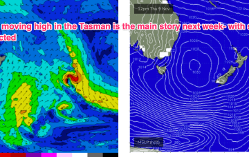
The pattern established on Mon is now well entrenched with a slow moving high in the Tasman slowly being squeezed on the western flank by approaching trough systems. A weak ridge up the sub-tropics has a lighter E’ly flow with stronger N-NE winds south of the MNC down to the South Coast. We’ll see this pattern with increasing NE windswell in Central NSW and some workable trade swell in the sub-tropics. A strong frontal progression is expected to provide a series of S swells next week.
/reports/forecaster-notes/sydney-hunter-illawarra/2023/11/06/week-nly-winds-and-increasing-ne
freeride76
Monday, 6 November 2023
The high initially weakens with a lighter onshore flow before re-strengthening as it approaches New Zealand and has the pressure gradient tightened on the western flank by the complex trough systems. That will produce a N’ly flow, expected to increase as the week goes on with increasing NE windswell late in the week and early weekend.
/reports/forecaster-notes/sydney-hunter-illawarra/2023/11/03/slow-moving-high-next-week-leads-small
freeride76
Friday, 3 November 2023
That NE windswell looks to be persistent under the slow moving pattern with high pressure drifting towards New Zealand. We should see an uptick in size through the second half of next week.
/reports/forecaster-notes/sydney-hunter-illawarra/2023/11/01/easing-swells-the-rest-the-week-onshore
freeride76
Wednesday, 1 November 2023
The deep Tasman low near the North Island has now dissipated and left the building with a small low in the Central/Southern Tasman supplying some S swell and an even smaller trough of low pressure off the Far North Coast. This pattern remains slow moving as large high slowly approaches from South of the Bight and multiple inland troughs supply unstable weather.