Fun couple of days before onshore winds move in

Western Australian Forecast by Craig Brokensha (issued Monday May 6th)
Best Days: Tomorrow ahead of sea breezes, Wednesday
Features of the Forecast (tl;dr)
- Moderate sized mid-period W/SW swell building tomorrow, peaking overnight, easing slowly Wed
- E/SE-E tending SW winds tomorrow, gusty E/NE tending variable winds Wed
- Strong E/NE-NE winds Thu, easing
- Strong N winds Fri with a building N windswell
- Strong but easing NW tending W/NW winds Sat with a large stormy W swell
- Easing swell Sun with weaker onshore winds
- Reinforcing large W/SW swell Mon with S/SW winds (possibly S/SE early to the north)
Recap
Metro locations performed best on the weekend with the cleanest conditions and a good amount of swell to 2-3ft Saturday in Mandurah, 2ft+ across Perth, easing into yesterday.
The South West saw large surf but winds limited options to protected spots which were smaller.
This morning the swell is down a little more with OK conditions across the South West for the keen and fun 2ft sets across the metro locations again.
This week and weekend (Apr 7 - 12)
The next couple of days are worth making the most of before we see winds turn onshore thanks to the arrival of the first mid-latitude frontal progression of the season.
As touched on in last week’s notes, an inconsistent mid-period W/SW swell is due to build through tomorrow, peak into the evening and then ease on Wednesday.
The South West should build to 4-6ft later tomorrow with 1-1.5ft sets to the north, easing from a similar size on Wednesday morning.
Local winds will be favourable and E/SE-E tomorrow morning ahead of seabreezes, with Wednesday offering fresh E/NE tending variable winds.
Stronger E/NE-NE winds are due into Thursday but with fading sets from 3ft or so.
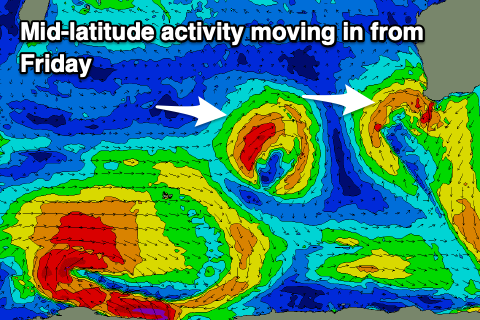
The strengthening winds out of the north-eastern quadrant will be feeding into a deepening trough ahead of a cold front, with a mid-latitude low due to form off our doorstep Friday, bringing strengthening N’ly winds that will then shift NW and then W/NW while easing Saturday.
The strong to gale-force winds directly off our coast will kick up a localised, stormy swell for the weekend, coming in at 2-3ft in Perth, 3-4ft across Mandurah and 10ft or so into the afternoon Saturday across the South West.
Easing surf is expected on Sunday but with persistent strong W’ly winds as the next approaching front moves in.
This and following activity into early next week looks generally weak, with stormy waves in the 10ft range due to continue across the South West, 3-4ft across Mandurah and 2-3ft in Perth along with improving winds on the backside of the activity. At this stage Wednesday might offer the cleanest conditions but we’ll keep an eye on this.