Slowish outlook continues

Western Australian Surf Forecast by Craig Brokensha (issued Friday April 5th)
Best Days: This afternoon selected spots, tomorrow morning in the South West, Monday morning/Tuesday morning/Wednesday morning/Thursday morning in the South West
Features of the Forecast (tl;dr)
- Inconsistent SW groundswell for this afternoon with fresh N'ly winds, easing later
- Easing groundswell tomorrow with gusty E/SE-SE tending strong S winds
- Small-moderate sized, mid-period S/SW swell building Sun with strengthening S/SE winds
- Moderate sized, mid-period SW swell building Mon PM with fresh, morning E/SE-SE winds ahead of strong sea breezes
- Easing swell Tue with fresh E/SE winds ahead of sea breezes
- Reinforcing SW swell Wed with gusty E/SE winds ahead of sea breezes
- Small mid-period S/SW swell Thu AM with gusty E winds ahead of sea breezes
Recap
A drop in swell yesterday morning back to 2ft to occasionally 3ft across the South West yesterday morning, kicking a little this morning back to the 3ft range.
A new, inconsistent SW groundswell is due this afternoon across the South West, reaching 4-5ft as winds shift N'th while remaining fresh, only easing in strength late.
To the north it's been tiny.
This weekend and next week (April 6 - 12)
Looking at the weekend ahead, and this afternoon's inconsistent SW groundswell is due to ease back through tomorrow morning, though still be around 3-5ft across the South West magnets with tiny options to the north.
Winds look favourable and fresh from the E/SE-SE before sea breezes kick in.
Into Sunday, a small pulse of mid-period S/SW swell should build to 4ft+ on the sets into the afternoon across the South West, generated by a weak front projecting towards us today.
The morning looks a little smaller and more to 3-4ft under fresh to strong S/SE winds, strengthening through the day.
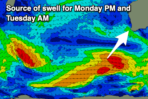
Early Monday looks temporarily smaller with an improvement in winds, shifting E/SE-SE and coming in fresh, while into the afternoon, a new pulse of mid-period SW swell is due.
This will be generated by a healthier, though still relatively weak frontal system moving in from the Heard Island region today and tomorrow.
Strong W/NW winds, followed by trailing W/SW winds should generate a moderate sized pulse of swell for the afternoon to 4-5ft+, easing back Tuesday from 4-5ft. Perth and Mandurah unfortunately look to remain tiny and to 1-1.5ft
Fresh E/SE winds will create clean conditions Tuesday morning, with similar winds Wednesday as the swell becomes smaller.
Longer term, the outlook remains slow with the westerly storm track being focussed away from the Western Australian region. This will result in slow surf for the start of the Margaret River Pro, but more on this Monday. Have a great weekend!