Large surf for tomorrow morning with an improved wind outlook

Western Australian Surf Forecast by Craig Brokensha (issued Friday March 29th)
Best Days: This morning in the South West, tomorrow morning, Sunday protected spots, Monday morning in the South West, Tuesday morning in the South West
Features of the Forecast (tl;dr)
- Large mix of W/SW swells building this afternoon with sea breezes, peaking tomorrow morning, easing into the PM and further Sun
- Light, E-E/NE tending N/NE winds tomorrow AM in the South West ahead of SW sea breezes (SE to the north)
- Strengthening S/SE winds Sun
- Easing surf Mon with strong SE tending E/SE winds, back to the S/SE into the PM, similar Tue
Recap
Early light winds offered clean surf yesterday morning with a small pulse of new swell to 3-4ft on the South West magnets, tiny to the north. Winds strengthened from the SW through the day, creating deteriorating conditions.
Today, we've got morning light winds again and small 3ft waves across the South West magnets, though some new W/SW groundswell is due to start building through the day. The Cape Naturaliste wave buoy now on the way up and bigger sets are showing across the reefs.

Sets on the build this AM
This weekend and next week (Mar 30 – April 5)
Today's building energy should be the start of a large mix of W/SW swell that's due to peak tomorrow morning across the state. There'll be a mix of long-period groundswell and mid-period energy, generated by a strong, northward projecting frontal system, high into the Indian Ocean this week.
Weaker bursts of W/SW winds following the gales linked to the groundswell should produce some additional mid-period energy. Size wise, the South West should come in around 8ft tomorrow morning with 3ft sets across Mandurah and 2ft+ waves across Perth.
Winds tomorrow morning are now looking more favourable with a light E-E/NE tending N/NE breeze due in the South West, SE-E/SE to the north ahead of sea breezes which will be fresh from the SW.
The swell should ease Sunday from 5-6ft across the South West and 2ft on the sets to the north with strengthening S/SE winds due. This will favour protected spots.
A further drop in swell is still due early-mid next week, slowed only marginally by small pulses of mid-period S/SW swell generated by weak, late forming fronts to our south-west.
Winds will swing more SE-E/SE on Monday, remaining strong, similar Tuesday morning. Hunt the magnets that have a bit of wind protection for the best surf.
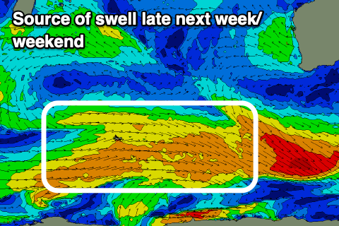
Unfortunately there's nothing significant surf wise due until late next week/weekend, and this only looks to be in the moderate size range. More on this Monday. Have a great weekend!