Classic winter pattern on the make

Victorian Surf Forecast by Ben Matson (issued Monday April 22nd)
Features of the Forecast (tl;dr)
Recap
Easing onshore winds on Saturday accompanied abating winds, with 3-4ft sets easing to 2-3ft west of Melbourne, bigger and bumpier east of Melbourne. Sunday saw small clean 2ft waves west of Melbourne under light offshore winds, and conditions improved east of Melbourne too. This morning we've got nice conditions across both coasts with a new swell rebuilding back jump into the 2-3ft mark west of Melbourne, with 4ft sets east of Melbourne.
(Please note: FC Notes will be variable in delivery this week as Craig is on paternity leave)
This week (April 23 - 26)
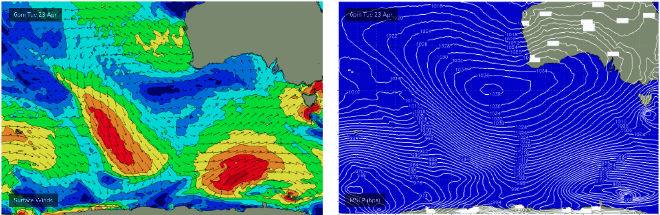
A strong winteresque frontal progression will deliver plenty of waves throughout the state this week.
The first front is due to push through overnight Tuesday, sourced from a cut-off low currently tracking through the Bight. Ahead of it we’ll see freshening N’ly winds through the morning tend NW into the afternoon, allowing for clean conditions across the open beaches early on.
Today’s swell is expected to slowly ease, we may see some stray 2-3ft sets in Torquay early Tuesday morning, but size will throttle back as the day progresses. East of Melbourne should offer fun waves for early surfers with 3-5ft sets on offer ahead of the easing trend.
The next series of fronts will originate from polar latitudes and will approach from the south-west (rather than the west, as is expected tomorrow). As such, strong SW winds will dominate all coasts on Wednesday. We may see a brief period of early W’ly winds in Torquay but it’s likely that we’ll see plenty of leftover wobble through the lineup, so keep a lid on expectations regarding wave quality.
The good news is that size should rebuild back up to 4-5ft here, and there’ll also be small options across the sheltered points west from Torquay - as well as Western Port and other protected locations east of Melbourne (expect poor 6-8ft waves at open beaches).
Another front will push through Bass Strait overnight Wednesday, maintaining fresh SW winds throughout the region into Thursday, though we should see a reasonable period of morning W/NW winds along the Surf Coast. I’m not expecting much deviation in side from Wednesday, with steady 4-5ft surf across most of the exposed spots around Torquay, and small clean waves inside Western Port (exposed beaches again too big with bumpy 6-8ft surf).
Another strong polar low developing south of WA and SA on Tuesday (see below) then looks to deliver the best swell in this sequence, mainly due to its more eastern position (and north-east track) which will occur inside the state’s SW thru’ S/SW swell window. This will allow for a little more size across the Surf Coast, compared to comparable storms riding more north in latitude (or developing further west in longitude).
Furthermore, we’ll see a weakening of the pressure gradient as the frontal conveyer belt moves to the east, so local winds will become much lighter, and the Surf Coast should see a nice spell of light morning W/NW thru’ NW winds.
The leading edge of this swell will arrive through Friday morning and should provide solid 5-6ft+ sets across the Surf Coast by the afternoon (i.e. occasional 6-8ft bombs at the swell magnets), with 6-8ft+ surf east of Melbourne and good waves inside Western Port again. Expect slightly undersized surf early morning.
This weekend (Apr 27 - 28)
Although the storm track will move out of our primary swell window later this week, strong peripheral activity will maintain plenty of surf throughout the state this weekend.
Friday’s strong surf will ease slowly through Saturday from 4-5ft to 3-4ft on Saturday (west of Melbourne), before levelling out at around 3ft for Sunday - both days seeing light to moderate NW thru’ W/NW winds.
East of Melbourne looks tricky for locations east of Melbourne. Light winds on Saturday will be accompanied by too much size for the open beaches and surf size will be throttling back inside Western Port, so you’ll have to scout around for the best options - but this looks like the pick of the weekend as Sunday looks to be too small for protected locations and too wind affected for exposed spots.
Next week (Apr 29 onwards)
Another strong series of fronts is lining up to push below the state this weekend, setting up another strong swell event for the first half of next week.
More on this in Wednesday's update.
Comments
ah who doesn't love mid autumn in vic, water temp still ok, swell after swell and the crowds are dropping
Dunno about crowds dropping.
Off and running again, more juicy swell with lightish winds.
Thanks Ben. AW