Large swells inbound with tricky winds

Victorian Surf Forecast by Craig Brokensha (issued Monday April 8th)
Best Days: Today Surf Coast, Wednesday morning Surf Coast, Thursday morning Surf Coast, Friday morning Surf Coast, Saturday morning Surf Coast, Sunday morning
Features of the Forecast (tl;dr)
- Moderate + sized mid-period W/SW-SW swell tomorrow with gusty SW-S/SW winds (very slim chance early W/SW Surf Coast)
- Easing swell Wed with early W/NW winds, shifting S/SW by late AM
- Large S/SW groundswell Thu AM, easing through the day
- Fresh S/SW-SW winds Thu (likely W/NW early Surf Coast)
- Moderate + sized S/SW groundswell for Fri PM, easing Sat
- Light-mod SW winds Fri, W/NW early on the Surf Coast
- Light-mod S/SW winds Sat AM, tending S/SE (likely W/NW early Surf Coast)
- Moderate sized + S/SW groundswell Sun with NE tending SE winds
Recap
A generally poor to average weekend of surf for the region with onshore winds for the Surf Coast, workable to the east for the keen on Saturday morning, bigger and bumpy yesterday morning as a late pulse of strong S/SW groundswell Saturday - eased through the day.
This morning we've got cleaner conditions on the Surf Coast along with easing 2-3ft sets, 3-4ft to the east and wind affected.
This week and weekend (Apr 9 - 14)
Today's offshore W/NW-NW winds will hold until later afternoon, when a gusty W/SW-SW change is due, thanks to a weakening front pushing up and across us, linked to tomorrow's lift in mid-period swell.
Before this front weakened, a great fetch of near-gale-force W/SW winds were being generated most of the weekend through our western and south-western swell windows.
A moderate + sized swell should come in at 4-5ft on the Surf Coast with 6ft+ sets to the east but with strong S/SW winds in the wake of late this afternoon's change. There's the tiniest of chances for a lighter W/SW breeze early on the Surf Coast but it looks unlikely.
As touched on last Friday, Wednesday looks to be a much better chance for a surf with morning W/NW winds, shifting S/SW later morning and strengthening.
Easing sets from 3-4ft are due on the Surf Coast with 5-6ft waves to the east.
Wednesday's change will be linked to the next swell generating frontal system, and this one is the most significant of them all.
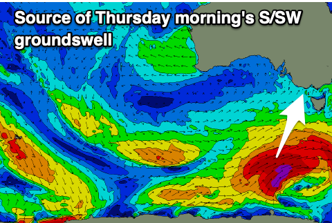
Currently, a polar front that's south-southwest of Western Australia is due to form into a significant polar storm this evening, with a fetch of severe-gale to storm-force SW winds firing up through our southern swell window, projecting towards Tasmania.
This will then be followed by secondary fronts, generating additional fetches of severe-gale SW winds in our southern swell window, south-west of Tasmania. This activity is thanks to a strong node of the Long Wave Trough forming east of us, steering and strengthening polar frontal systems up towards Tasmania and New Zealand.
Looking at the swell, and the first, strongest storm will generate a large, long-period S/SW groundswell for Thursday morning, with the Surf Coast due to come in a strong 6ft (8ft cleanups on the magnets) with 8ft sets to the east, easing through the day.

Friday morning looks smaller ahead of a good pulse of reinforcing S/SW swell into the afternoon, with sets maintaining 4-5ft on the Surf Coast, 6ft+ to the east.
Looking at the local winds, and Thursday looks dicey with moderate to fresh S/SW-SW winds, but there's likely to be a window of early W/NW winds on the Surf Coast, with Friday seeing lighter S/SW-SW winds and a more reliable chance of early W/NW winds to the west.
Saturday looks to play out similar to Friday wind wise in the morning, with S/SE winds into the afternoon. The swell will be easing out of the S/SE, back from 3-4ft on the Surf Coast, 5-6ft to the east.
Into Sunday, we've got another pulse of S/SW groundswell from the next round of polar frontal activity firing up under the country, south-west of Tasmania later in the week.
This should generate a moderate sized S/SW groundswell with NE winds, but we'll have a closer look at this on Wednesday.