Fun Sunday, large back to back swells next week

Victoria Forecast by Craig Brokensha (issued Friday 22nd July)
Best Days: Surf Coast Sunday, Monday, Tuesday morning, Wednesday, Thursday
Recap
Excellent waves across the Surf Coast easing from 3-5ft yesterday, while exposed locations to the east saw 6ft to occasionally 8ft sets through the morning, only working at a selected few breaks.
This morning the swell was smaller and easing from 3ft on the sets across the Surf Coast and 3-5ft on the Mornington Peninsula with freshening NW winds.
A W'ly change is due through the afternoon but with no increase in real size due.
This weekend and next week (Jul 23 - 29)
While this afternoon's W'ly change isn't due to generate much in the way of swell, the secondary stronger frontal system that's due to push through early tomorrow morning has now been upgraded again.
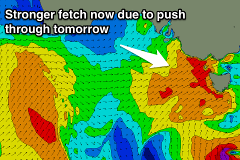 We've seen the models struggling to grasp the strength of this system, but now less than 24 hours out, it's looking much better.
A fetch of strong to gale-force W/SW winds will be form just west-southwest of Tassie this afternoon and project up and into us, kicking up a moderate to large sized increase in mid-period W/SW swell through tomorrow afternoon (windswell for the morning).
The Surf Coast should build to 4-5ft+ later in the day, much smaller early and probably only around 2ft, with the Mornington Peninsula reaching 6-8ft.
Conditions will be poor though with fresh to strong W/SW winds all day (arriving near dawn).
Another approaching front will quickly steer winds around to the N/NW Sunday as the swell quickly abates from 4ft and 6ft respectively.
Into the afternoon a new long-range SW groundswell is due from a polar fetch of SW gales currently well south of WA.
This should keep the surf up around 3ft on the sets across the Surf Coast through the afternoon and 5-6ft on the Mornington Peninsula, easing back from 2-3ft and 5ft respectively Monday morning.
Strengthening W/NW winds on Monday will continue to favour the Surf Coast.
Now, as touched on last update, an elongated node of the Long Wave Trough is forecast to spread out across our swell window through next week.
This will direct strong front after front up from the polar shelf towards us, the first forming this evening in the Heard Island region. This will generate a fetch of severe-gale to storm-force W/SW winds before projecting north-east towards us while weakening a touch but broadening in scope Monday.
The front will push across us Monday evening, with an increase in moderate to large mid-period W/SW energy through Tuesday, with the groundswell due to fill in overnight, peaking Wednesday morning.
The Surf Coast should build to 5-6ft through Tuesday afternoon with 8ft+ sets on the Mornington Peninsula under gusty W/NW tending W/SW winds.
Wednesday morning should see similar sized sets continuing across both coasts with better offshore NW tending W/NW winds.
Into Thursday another large pulse of SW groundswell is due from a fetch pre-frontal W/NW gales and then post-frontal severe-gale to storm-force W/SW winds moving through our swell window Tuesday and Wednesday.
The Surf Coast at this stage is expected to kick back to the 6ft range into the afternoon and 8ft on the Mornington Peninsula under persistent W/NW winds, easing back from Friday into the weekend.
We'll have a closer look at all of this Monday though. Have a great weekend!
Comments
13th Beach ain't looking too shabby this morning.
How's this long straight wall, well offshore! Deceptively fun. Don't think I've ever seen anyone out here though (not at this particular reef, anyway).
Good tubes here today. Some steep windy take offs
Regarding wind observations, if north is 0 degrees, does thag then have 12.25 degrees leeway before it will read NNW/E. Cause its reading North on morn pen but most defiantly aint.