Poor end to the week, large and improving slowly on the weekend

Sydney Hunter Illawarra Forecast by Craig Brokensha (issued Wednesday April 3rd)
Best Days: Selected spots Saturday morning, Sunday morning, Monday morning, Tuesday morning
Features of the Forecast (tl;dr)
- Small-moderate sized mix of S'ly swells building tomorrow, easing Fri
- Moderate S/SE winds, strengthening tomorrow
- Rapid increase in stormy E'ly swell Fri with fresh-strong E/SE tending stronger E/NE winds
- Large E/NE swell Sat with strong, pre-dawn NE winds, easing and tending N, then fresher N/NE-NE into the PM (check back Fri for specifics)
- Moderate sized, easing E/NE swell Sun with moderate N/NW winds ahead of NE sea breezes
- Smaller Mon with W/SW tending NE winds
Recap
A small mix of peaky NE windswell and S swell faded through yesterday with early average conditions, improving slowly through the day and more so late, while becoming tiny.
This morning was crisp and clean but tiny, while a small pulse of weak S’ly swell has come up this afternoon.
This week and next (Apr 4 - 12)
The end of this week is looking poor as a deepening coastal trough to our north starts to slide south, down the East Coast.
This will bring strengthening S/SE winds through tomorrow (moderate in the morning) along with a small mid-period S’ly swell. The Northern Beaches might see early S/SW winds but it won’t be worth worrying about.
Some slightly stronger S’ly groundswell is due into the afternoon, generated by S’ly gales around a low entering the southern Tasman Sea last night, but with the strengthening onshore winds, there’ll be nowhere to surf.
Into Friday, the trough will start to shift further south, swinging winds E/SE while remaining fresh to strong, strengthening late from the E/NE as it continues on its way.
The swell will also build out of the E thanks to strengthening E’ly winds feeding into the trough, with windswelly 2-3ft waves early, due to reach a stormy 4-5ft+ by the close of play.
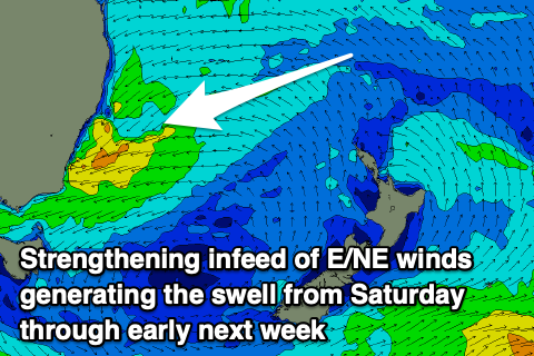
As the low continues drifting south on the weekend, it will continue to deepen, with stronger bursts of near gale-force E/NE winds due to generate some larger surf on Saturday, likely coming in at 6ft to occasionally 8ft, with larger surf down the South Coast.
We’ve got a slower movement of the system as a whole, with the low pressure centre forming further inland. What this is means is that winds aren’t looking as favourable, likely strong NE pre-dawn Saturday, tending N’ly for a period during the morning and then back to the N/NE-NE into the afternoon. There's still some fluidity in the wind outlook so check back Friday for the latest.
It won’t be until Sunday that winds shift offshore, though only N/NW, favouring selected breaks over others before NE sea breezes kick in.
The swell should be starting to ease as the swell generating fetch continues south, with slowly easing sets from 4-5ft during the morning, (bigger down South) and back from a smaller 3-4ft on Monday.
Conditions look best Monday with a W/SW offshore, giving into afternoon sea breezes.
Looking at the rest of the week, and the E/NE swell will continue to ease slowly, thanks to an extended fetch of strong E/NE winds feeding into the coastal trough, from the Coral Sea.
We’re then looking at an extended run of S’ly swells from late week into next weekend and the following week as a strong node of the Long Wave Trough sets up camp across the southern Tasman Sea. More on this Friday.
Comments
Ho humm!
BOM Wollongong rain forecast for tomorrow is 130mm.
Not sure if something has changed at the Bureau, but not even in the swollen depths of La Nina did they ever predict rainfall that high.
We had a few instances where that much rain was recorded, however the BOM's FC was always more conservative. Not sure if their systems have changed since then or we can expect a right bucketing come tomorrow.
ACCESS hi-res forecasts..
A bit on! That's the accumulated precip from now to 11pm Friday.
Warragamba dam currently at 96% - going to be fun & games along the hawkesbury-nepean.
Might bring the washing in, eh?
I’m seeing the wind forecast for Saturday for other sources being 18knot NE all day and swellnet forecast is calling 7 knot…..hopefully it’s that later but I’m thinking it’s going to be howling all Saturday
As the trough 'peels' away from the coast winds should abate quickly through the morning though only likely tend N'ly and then back fresh N/NE-NE into the afternoon, stronger on the South Coast.
Nice one - will keep an eye on some novelty spots
GFS has just gone back to an offshore swing in the morning, see what EC brings up.
Going to sneak in a quick one before all hell breaks loose this arvo
Just had a paddle, even though short period, it was weak closeouts on the fast dropping tide. Ughh.
Managed a few 2/3 ft peaky ones before the SE kicked in better than nothing