Strong south swells this week

Southern Tasmanian Forecast by Craig Brokensha (issued Monday May 6th)
Best Days: Tomorrow morning, Thursday morning, Saturday morning, Sunday morning
Features of the Forecast (tl;dr)
- Inconsistent SW groundswell this afternoon and tomorrow, easing
- N/NW tending variable winds tomorrow
- Moderate sized S/SW groundswell building rapidly Wed, easing Thu
- Early variable winds Wed, tending strong E/SE, then easing and tending E/NE late
- NW winds Thu AM, shifting S
- Moderate sized S/SW groundswell for Fri AM, easing
- Light-mod W/SW tending fresh S winds Fri
- Easing swell Sat with variable tending S/SE winds
- Smaller Sun with W/NW tending variable winds
Recap
Friday’s swell eased back through Saturday with nice clean conditions and options all over, while a reinforcing pulse of S/SW energy maintained 2ft waves into yesterday, easing back to 1-2ft today.
This week and weekend (Apr 7 - 12)
Looking at the week ahead and we’ve got an upgrade in the S/SW groundswells due mid-late week thanks to inswinging polar frontal systems strengthening directly south-west of us over the coming days.
Firstly, an inconsistent W/SW groundswell is due this afternoon and tomorrow morning, generated by a distant polar low that formed east of Heard Island last week. 2ft sets are due across Clifton with a N/NW tending variable breeze.
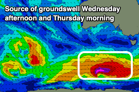
Now, looking at the stronger S/SW groundswells, and a frontal system currently swinging in under the country is forecast to generate a great fetch of severe-gale to storm-force W’ly winds, and a moderate sized pulse of S/SW groundswell for Wednesday, kicking rapidly to 4ft through the day. Winds are an issue though and look to strengthen from the E/SE during the morning (variable early), easing through the day and tending more E/NE on dark.
Thursday looks cleaner with easing levels of swell under a NW offshore, shifting S’ly late morning as a trough clips us. Easing sets from 3ft are due ahead of the new S/SW groundswell Friday morning.
Unfortunately Thursday’s trough will leave lingering W/SW tending S winds on Friday, and a secondary strengthening polar front looks to bring a less consistent but still strong 3-4ft of groundswell to the South Arm.
Saturday looks cleaner with easing 2-3ft sets and a variable W/NW-NW offshore.
The frontal activity looks to settle into the weekend resulting in a drop in energy through early next week with nothing of significance on the cards until later next week. We’ll have a closer look at this Wednesday though.