Plenty of swell but with tricky winds

Southern Tasmanian Surf Forecast by Craig Brokensha (issued Monday April 29th)
Best Days: Dawn tomorrow but more so Wednesday morning, Sunday morning
Features of the Forecast (tl;dr)
- Moderate sized mid-period SW swell tomorrow with dawn gusty W/NW winds, tending W/SW shortly after and then stronger SW
- Easing swell Wed with W/NW tending SW winds
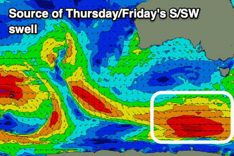
- New moderate sized S/SW swell Thu with gusty SW winds (possibly W at dawn)
- Easing swell Fri with moderate S/SW-SW winds
- Moderate sized S'ly groundswell building Sat PM with S/SW winds, easing Sun with N tending SE winds
Recap
A drop in swell from Friday with clean, fun 2ft+ waves Saturday, smaller yesterday and tiny into today with 1-1.5ft peelers.
This week and weekend (April 30 – May 5)
Looking at the week ahead and we've got plenty of swell due, but winds look to be an issue as the strengthening polar frontal systems push up past the south-eastern corner of a strong high in the Bight.
This will bring unfavourable winds from the south-western quadrant, though each morning over the coming days should offer a window of early favourable winds.
Tomorrow we're looking at gusty W/NW winds at dawn, shifting W/SW shortly after and then strong SW late morning onwards.
A lift in swell is due from the front bringing the average winds, with Clifton due to come in around 3ft tomorrow, easing from 2-3ft Wednesday morning.
A longer window of W/NW winds are due Wednesday morning, shifting SW later morning.
Thursday looks dicey with a general SW flow (possibly W'ly at dawn), holding out of the SW-S/SW on Friday.
This will be along with the next increase in S/SW swell energy, generated by a great polar fetch of strong to gale-force W/NW tending W winds.
This should generate a good 3ft+ of swell for Thursday, easing from 3ft Friday morning.
A more southerly angled swell is due into the weekend, as a strong polar low fires up south of us Friday, generating a fetch of severe-gale to storm-force W/SW-SW winds.
The swell should arrive into Saturday afternoon with a pulse to 2-3ft due, easing from a similar size on Sunday morning.
It looks like onshore S/SW winds will persist on Saturday, more variable N'ly Sunday, and this looks to be the pick of it.
Longer term, some less consistent but fun swells are on the cards for next week with better winds. More on this Wednesday.