Large swells inbound with workable winds

Southern Tasmanian Surf Forecast by Craig Brokensha (issued Monday April 8th)
Best Days: Wednesday morning, Friday, Saturday, Sunday
Features of the Forecast (tl;dr)
- Small mid-period W/SW swell tomorrow with fresh W/SW-W winds
- Large SW groundswell building Wed PM, peaking overnight, still large and easing from the S/SW Thu
- W/NW tending fresh W/SW winds Wed
- Fresh W/SW tending SW winds Thu
- Moderate + sized, reinforcing S/SW swell for Fri with N/NW-NW tending variable winds
- Easing surf Sat with NW tending variable winds
- Moderate sized S/SW swell for Sat PM and Sun AM with N tending variable winds
Recap
As most are now probably aware (check the WOTD), Saturday's strong pulse of upgraded SW groundswell came in right on cue with 2-3ft waves early, pulsing to 4ft or so through the afternoon as winds shifted N/NE.
This provided an epic session at the big wave spots, with the swell fading into Sunday from 2ft+ with early light winds and a big morning high tide.
Today was even smaller with fading sets from 1-1.5ft, again with the big morning high.

Small leftover waves today
This week and weekend (Apr 9 - 14)
Looking at the week ahead and we've got a very active period on the cards thanks to a strong node of the Long Wave Trough setting up camp just east of us.
This will see polar frontal systems strengthening immediately south-west of us, pushing up and under the state all week, generating numerous pulses of moderate to large swell from Wednesday through the weekend and next week.
Firstly, a small pulse of mid-period W/SW swell is due tomorrow, generated by a healthy but northerly positioned frontal system. 2ft surf is due across Clifton with winds not being too ideal, gusty from the W/SW-W. Protected spots will be best.
Into Wednesday, a large pulse of SW groundswell is due, generated by a strengthening polar low to our south-west this evening.
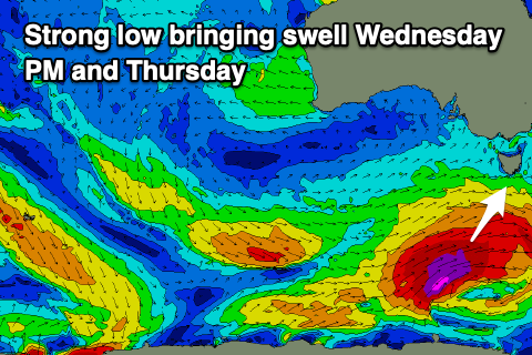
A great fetch of severe-gale to storm-force W/SW winds will be projected east-northeast, generating a significant increase in swell later Wednesday, kicking to 4-6ft by dark, peaking overnight and easing from a similar size Thursday morning.
Local winds look favourable for protected spots Wednesday with a W/NW tending gusty W/SW breeze Wednesday, less favourable Thursday and W/SW tending SW.
Friday morning will become cleaner, but a new pulse of reinforcing S/SW groundswell is due to fill in, generated by secondary frontal activity behind the polar low. Fetches of severe-gale W/SW-SW winds are forecast to be generated in our southern swell window, with Clifton likely to hold 4ft or so, easing into the afternoon and Saturday from 3ft.
A light N/NW offshore is due Friday morning, tending variable through the afternoon with similar winds due Saturday.
We'll then see the next strengthening frontal progression generating some new moderate sized S/SW groundswell for Saturday afternoon and Sunday, pushing to 3-4ft or so. We'll have to confirm this during the week as well as the timing and sizes of Wednesday through Friday's pulses. Check back then.