Upgrade in tomorrow's swell

Southern Tasmanian Surf Forecast by Craig Brokensha (issued Friday April 5th)
Best Days: Tomorrow, early Sunday, Monday for the keen, Thursday morning, Friday morning
Features of the Forecast (tl;dr)
- Mod-large pulse of SW-S/SW groundswell building tomorrow, peaking into the PM
- Light-mod N tending fresh E/NE-NE winds
- Easing swell Sun with early variable winds, tending SW mid-AM, freshening into the PM
- Smaller Mon with N/NW tending NW, then W/NW winds
- Small-mod sized W/SW swell Tue with fresh W/SW tending stronger SW winds
- Mod-large SW groundswell building Wed with SW winds, easing Thu with W/NW tending S/SW winds
Recap
The swell eased back into yesterday morning before pulsing back in size through the afternoon, holding 2-3ft this morning.
This weekend and next week (Apr 6 - 12)
Following yesterday afternoon's and this morning's swell, we're looking at an easing trend into this afternoon and evening, with a strong pulse of SW tending S/SW groundswell due to fill in tomorrow.
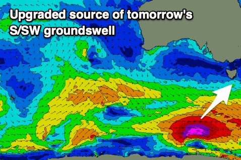
We've got an upgrade in the expected swell as well with the low at the core of the swell generating system, producing satellite confirmed storm-force winds.
This on the back of pre-frontal gale to severe-gale W/NW winds should produce a large mix of mid-period and long-period SW groundswell for tomorrow, building steadily through the morning, peaking into the afternoon.
With this, sets to 4ft+ are now likely tomorrow afternoon across Clifton, 2-3ft early in the morning and with a light to moderate N'ly wind, tending E/NE-NE and freshening into the afternoon.
The swell will ease back through Sunday from 2-3ft, down to 1-2ft later in the day.
Winds are tricky but should be variable at dawn on Sunday, with a trough bringing a shallow SW change by mid-morning, freshening into the afternoon.
Monday looks smaller with slow 1ft to occasionally 2ft sets, along with morning N/NW tending NW and then W/NW breeze, ahead of a late change.

The change will be linked with the first in a series of strengthening frontal systems moving in from the west, under the influence of a strengthening node of the Long Wave Trough across the southern Tasman Sea.
This will see polar storms generating severe-gale to storm-force W/SW-SW winds through our south-western and southern swell windows, generating large pulses of swell from Wednesday through Sunday and early the following week.
Winds for each pulse look generally W/NW to SW with each passing front, but we'll have a closer look at this on Monday. Have a great weekend!