Weak W/SW swell for the weekend

Southern Tasmanian Surf Forecast by Craig Brokensha (issued Wednesday January 24th)
Best Days: Saturday morning, Sunday morning
Features of the Forecast (tl;dr)
- Building W/SW windswell later Fri with gusty W/NW tending strong W/SW winds
- Peak in mid-period W/SW swell Sat, easing Sun
- Moderate W/NW winds Sat AM, strong W/SW into the PM, W/NW tending SE Sun
- Tiny Mon with NW tending S/SE winds
Recap
Fun waves yesterday with clean conditions and 1-2ft surf across Clifton, similar this morning though sea breezes have since developed.
This week and next (Jan 25 - 28)
Looking at the end of the week and the surf will bottom out into tomorrow under gusty offshore winds, only increasing again later Friday but more so Saturday.
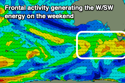
The source of weak W/SW swell will be a weakening frontal system moving in from the west, bringing strong W/SW winds while passing under us Friday.
There might be a 1-2ft wave seen on dark Friday but with strong W/SW winds, better Saturday and coming in at 2ft with W/NW winds, shifting back W/SW through the day.
Sunday looks smaller and easing from a weak 1-2ft max but with morning W/NW winds again.
Following this episode of localised W/SW swell, trickier levels of W'ly swell are on the cards, generated by flukey systems moving in from the west, dropping east-southeast through our swell window.
ECMWF looks weaker than GFS at this stage so lower the expectations but check back here on Friday for the latest.