Fading swell on the Mid Coast, best down South

South Australian Forecast by Craig Brokensha (issued Monday May 6th)
Best Days: Keen surfers Mid Coast tomorrow, South Coast every morning this week up until Sunday (tiny)
Features of the Forecast (tl;dr)
- Inconsistent SW groundswell this afternoon and tomorrow morning, easing
- NE tending SE winds tomorrow
- Moderate sized, inconsistent S/SW groundswell kicking later Wed, peaking Thu AM, easing
- E/NE-NE tending SE winds Wed and Thu
- Late pulse of small-mod sized, S/SW groundswell Fri, easing through Sat
- Variable tending S winds Fri
- Variable tending SE winds Sat, NE tending SE Sun
- N/NE winds Mon with tiny surf
Recap
The swell faded into the weekend across the South Coast, with the swell magnets performing best on Saturday, with the swell bottoming out Sunday.
The Mid Coast was flat on Saturday but our new mix of westerly swells filled in yesterday, providing inconsistent but fun 2ft sets across the magnets, best as the tide filled in before getting too high.
This morning the swell is easing and to 1-2ft across the gulf with a bit more size down South to 2-3ft, but bumpy.

Bumpy new swell yesterday arvo
This week and weekend (Apr 7 - 12)
East, east, east.
High, high, high.
In short that’s the summary for the coming week or so with persistent high pressure due to dominate our local weather and surf outlook.
Various evolutions of high pressure are due to sit just south-west of us this week before slowly moving east, under us on the weekend.
With this we’ll rely on long-range groundswell energy, as is the case today and tomorrow morning, with some better, S/SW groundswell energy due mid-week and on the weekend, emanating off strong polar fronts skirting around the southern flank of the highs.
Looking at the pulse today and tomorrow morning, this was generated by a strong but distant polar low that formed east of the Heard Island last week, and inconsistent 2-3ft sets should continue across Middleton tomorrow morning, easing into the afternoon with fading 1-1.5ft surf on the Mid Coast.
Conditions will be favourable for the beaches tomorrow morning with a NE offshore ahead of sea breezes, favourable most of the day in the gulf.
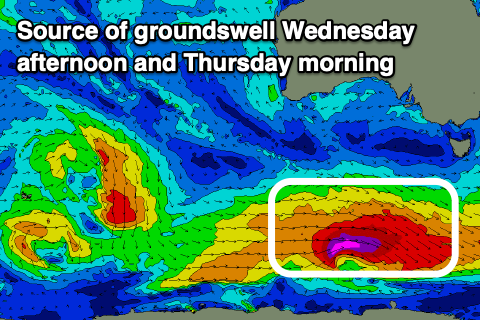
Later in the day Wednesday, and more so Thursday morning, a good pulse of new S/SW groundswell is due, generated by one of the above mentioned frontal systems skirting around the base of the high. This strengthening system will be strongest once under Tasmania, but the early developments should produce a good kick in size later Wednesday to 3ft across Middleton, easing from 3ft to possibly 4ft Thursday morning. The Mid Coast won’t see any size from this swell or the next.
Winds on Wednesday morning look more E/NE-NE ahead of sea breezes, with Thursday seeing variable E/NE-NE winds before sea breezes kick in.
Friday morning looks temporary smaller and with variable winds that look to increase a little more from the S’th through the day.
Our next pulse of groundswell is due into Friday afternoon and Saturday morning, produced by a similar though slightly more distant polar storm, with fetches of severe-gale to storm-force winds due. The size looks a touch smaller across our region, but still good and to 3ft across Middleton, but less consistent.

Variable winds are again due Saturday morning ahead of sea breezes, with NE tending SE winds on Sunday as the swell backs off from a small 2ft.
Looking at next week, and winds should shift more to the north-eastern quadrant Monday, then north-west thanks to the high moving east, pushed out by approaching frontal activity. This should bring some new swell energy mid-week but with what looks to be onshore winds. More on this Wednesday.