Upgrade in the coming westerly swell

South Australian Forecast by Craig Brokensha (issued Friday May 3rd)
Best Days: South Coast tomorrow morning, Mid Coast Sunday, Monday and for the keen Tuesday, South Coast Monday and Tuesday mornings
Features of the Forecast (tl;dr)
- Easing S/SW swell tomorrow with N/NW-N/NE winds ahead of sea breezes
- Moderate + sized W'ly swell building Sun, easing slowly Mon/Tue
- Inconsistent W/SW groundswell building Sun PM, peaking Mon with a reinforcing pulse in the mix, easing slowly Tue
- Local offshore winds Sun AM, giving into sea breezes and tending S/SE mid-late PM on the Mid
- E/NE tending SE winds Mon down South, E/SE-SE tending SE winds on the Mid
- N/NE winds down South Tue ahead of sea breezes, E/NE on the Mid in the AM
Recap
Peaky, lumpy conditions on the South Coast each morning with winds out of the east along with sets in the 3ft range while the Mid Coast has come in tiny.
This weekend and next week (Apr 4 - 10)
The current S/SW swell energy is due to ease into the weekend, and conditions will become cleaner as winds go variable N/NE-N/NW through the morning but with smaller, easing 2ft sets off Middleton, flat inside the gulf.
Into Sunday, our mix of W/SW swells are due to fill in, with the Mid Coast likely to be the pick of the regions, thanks to the swell for the South Coast only showing later in the day once sea breezes are in.
The tight, strong low that’s expected to generate the best pulse of W’ly swell, fired up to the south-west of Western Australia, and satellite imagery has come in quite impressive, with storm-force barbs spinning around the core of the system.
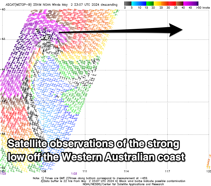
The low is now weakening off the WA coast, and we can expect a strong pulse of W’ly groundswell from this source on Sunday, likely now kicking to 2ft+ with the big incoming tide.
The swell should still be 2ft on the sets Monday but slowing and easing, backing off from 1-1.5ft Tuesday.
The South Coast will rely on the longer-range swells from strong storms in the Indian Ocean, with Monday expected to come in around 2-3ft across Middleton, easing from a similar size Tuesday morning.
Local winds on Sunday look offshore across both regions ahead of sea breezes, tending S/SE mid-late afternoon across the Mid Coast, with Monday seeing E/NE winds down South, E/SE across the Mid, tending S/SE-SE through the day.
As the swell eased Tuesday winds look to tend N/NE down South, E/NE on the Mid ahead of weak sea breezes.
Unfortunately, longer term there’s nothing significant on the cards thanks to blocking high pressure being dominant, keeping Southern Ocean storms at arms length to the region. This will bring smaller swells with winds out of the eastern quadrant, not very autumn like. More on this Monday, have a great weekend!
Also, in news just in, Adelaide's first wave pool gets the green light: https://www.swellnet.com/news/swellnet-dispatch/2024/05/03/the-break-surf-park-approved-south-australia
Comments
Aha what happened? This swell was talked up so much all week, then barely a 1ft ripple came through all Sunday
The good ol' fickle Mid Coast, WA came in big, but alas, the SA gulfs not too much. Still got to 2ft but slow..