Plenty of waves on the way; next week looking a treat

South Australian Surf Forecast by Ben Matson (issued Monday April 15th)
Features of the Forecast (tl;dr)
- Strong S/SW swell building Tues, easing Wed, favourable AM winds down south (tiny on the Mid)
- Average spell of waves Thurs thru' Sun
- Strong series of new groundswells showing from next Mon, peaking Tues/Wed, looking like a nice round of surf for the Mid
Recap
Great waves down south over the weekend with light morning winds and plenty of surf, around 3-4ft Saturday, building a little more through Sunday and now easing back from 3-4ft today. Unfortunately it’s been tiny on the Mid.
(Please note: FC Notes will be variable in delivery this week as Craig is on paternity leave and Steve is covering Margs)
This week (Apr 16 - 19)
No major changes to Craig’s notes from Friday - we’ve got a strong S/SW groundswell inbound tomorrow, that will lift wave heights up into the 5-6ft range across the Victor coast on Tuesday, before easing slowly through Wednesday.
A weak pressure pattern will result in light variable morning winds ahead of moderate afternoon sea breezes, so aim for an early session for the best waves - but there’ll be strong options all day, with even some of the more sheltered spots in towards Victor providing waves thanks to the more southerly swell direction.
We should see small waves across the Mid Coast on Tuesday but the swell direction isn’t favourable so expect long breaks between waves, and slow sets on the incoming tide, somewhere between 1ft to maybe 1-2ft if we’re lucky. Keep your expectations low here, it's not a high confidence event at all.
Wednesday’s easing size will be accompanied with a little oomph in the southerly wind but there should still be a period of variable conditions early morning, down south.
Thursday will herald smaller, slower conditions as a front passes to the south and freshens southerly winds about the region. We’ll see building S/SW swells into Friday from a broad though poorly aligned fetch associated with the parent polar low (well to the south) but conditions will be very average at Victor and this swell direction won’t be favourable for the Mid either, so keep your expectations low for the end of the week.
Tuesday and Wednesday are your best options this week, down south!
This weekend (Apr 20 - 21)
Average waves are expected this weekend with easing onshore Saturday and abating S/SW swells from whatever makes landfall on Friday.
Lumpy 3ft sets looks like the most likely option at Victor, with tiny surf on the Mid. Smaller waves are then expected on Sunday as winds become light and variable, so there’ll be options down south - but nothing amazing.
I’ll take a closer glance on the weekend’s outlook in Wednesday’s notes but right now it’s not worth getting to excited about.
Next week (April 22 onwards)
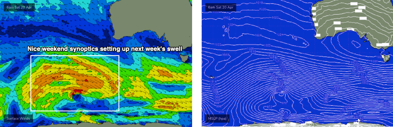
A powerful low/front sliding down the eastern flank of a LWT well to the west of WA from Wednesday thru’ Friday (this week) will set up the start of a decent groundswell run for next week.
The leading edge of the first pulse is due overnight Sunday, and it’ll be quite lengthy in period - but the unfavourable storm track will limit surf size across our region. We should see small 1-1.5ft sets in the gulf on Monday morning, and 2-3ft waves across the South Coast.
An impressive series of stronger, better-aligned followup fronts behind this - from Friday thru’ Monday below the continent - will then generate much better surf for the region, and better still, the swell direction will come around to the SW, which will favour the Mid for waves.
At this stage, a rough timeline has the swell trend building from late Monday through Tuesday and peaking Wednesday, pushing up into the 2-3ft range on the Mid Coast, with 4-6ft surf at Victor. The parent storms may end up being capable of more size, however they’ll be tracking reasonably far north in latitude (than is ideal, for Victor’s swell window, at least), so I’m going to shave off some size for now, and will reevaluate over the coming days as the model guidance firms up.
So.. start putting aside some flexi time for next week, it’s looking like we’ve got some great winter swell patterns on the way.
See you Wednesday!