Great weekend of surf, with one last large swell next week

South Australian Forecast by Craig Brokensha (issued Friday April 12th)
Best Days: South Coast today, tomorrow, Sunday, Monday and Tuesday morning, Mid Coast Tuesday for the keen, similar Wednesday morning
Features of the Forecast (tl;dr)
- Easing swell today, slowed Sat AM by a reinforcing S'ly swell
- Light local offshore winds ahead of weak sea breezes tomorrow
- Moderate sized, mid-period S/SW swell for Sun with N/NE winds ahead of weak sea breezes
- Easing swell Mon with variable offshor tending weak S/SW winds
- Large S/SW swell Tue with light, local offshore winds, with fresher sea breezes
- Easing swell Wed with SE tending S/SE winds, similar Thu
Recap
A large S/SW groundswell filled in across the South Coast yesterday with variable tending weak onshore winds but good to great waves between 5-6ft across the magnets. The Mid Coast was 1ft or so in the morning and pulsed to 1-1.5ft through the afternoon with a weak sea breeze.
This morning conditions are cleaner across all locations with tiny 1ft waves in the gulf and better 3-4ft surf down South. Sea breezes are only due to be weak this afternoon along with a late pulse of reinforcing S'ly swell but this will most likely be seen tomorrow morning.
This weekend and next week (Apr 13 - 19)
The current easing trend in swell from yesterday will be halted by the arrival of a good, mid-period S'ly swell into this evening, easing through tomorrow.
This was generated by a trailing polar front on the backside of the low linked to yesterday's swell, but later in our southern swell window.
It'll likely be less consistent but still 3ft to occasionally 4ft across Middleton, easing through the day (tiny in the gulf).
Variable winds are due tomorrow morning, likely tending light offshore, creating clean conditions ahead of weak S/SE sea breezes.
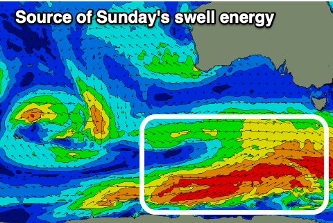
Moving into Sunday and a more consistent and reliable pulse of mid-period S/SW swell is due, generated by patchy but healthy fetches of strong to gale-force W/SW winds along the polar shelf, south-west of Tasmania.
This should pulse to 4ft across Middleton but hardly impact the Mid Coast, easing back Monday from 3ft+.
A light N/NE offshore will create excellent conditions Sunday morning ahead of relatively weak sea breezes, variable offshore Monday morning before tending light S/SW.
Moving into Tuesday, and our final pulse of large S/SW swell from the current run is due to fill in, peaking through the middle of the day/afternoon.
The source will be a deepening polar low, south of the country on the weekend, with a slow moving and broad fetch of W/SW gales due.

The swell should be in at dawn and reach 6ft across Middleton before lunch, easing slowly from 5-6ft on Wednesday morning.
The Mid Coast should also see plenty of size, coming in at 1-2ft on the favourable parts of the tide Tuesday, fading Wednesday.
It looks like local winds will be favourable and variable early Tuesday, NW down South and SE on the Mid, but a trough will bring a change and enhance sea breezes through the afternoon.
Wednesday will see winds swing around to the SE, favouring the Mid Coast, similar Thursday as the swell drops more. Following this, the outlook is quiet so make the most of the current conditions and swell. Have a great weekend!