Lots of swell this period with tricky but workable winds

South Australian Forecast by Craig Brokensha (issued Monday April 8th)
Best Days: Mid Coast tomorrow morning, South Coast Wednesday morning and likely Thursday and Friday mornings, Saturday and Sunday morning South Coast
Features of the Forecast (tl;dr)
- Moderate + sized SW swell tomorrow with S/SW winds (S/SE early on the Mid)
- Easing surf Wed with light SE tending SW winds on the Mid, W/NW tending S/SW down South
- Large S/SW groundswell for Thu AM, easing through the day
- Light-mod S/SW winds Thu, likely W/NW early South Coast
- Reinforcing, moderate sized S/SW groundswell late Fri, easing Sat
- Light S/SW tending S/SE winds Fri, possibly W/NW early down South
- NE tending SE winds Sat/Sun
- Moderate + sized S/SW groundswell Sun
Recap
The South Coast offered OK waves for the keen on the weekend with a drop in swell from Friday but with light S'ly winds, similar yesterday with a new pulse of S/SW groundswell from Saturday evening on the ease.
The Mid Coast hovered around 1ft on Saturday with tiny, bumpier waves yesterday.
Today the South Coast is smaller but nice and clean with 2-3ft sets across the Middleton stretch, tiny and lumpy across the Mid Coast. Make the most of this morning's clean conditions as an approaching front will bring a strong S/SW change mid-afternoon.
This week and weekend (Apr 9 - 14)
This afternoon's change will be linked to tomorrow's moderate + sized pulse of mid-period SW swell, with a great fetch of near-gale-force W/SW winds were being generated most of the weekend through our western and south-western swell windows.
This should come in around 4-5ft across Middleton with 1-2ft sets on the favourable parts of the tide.
Winds in the wake of today's change look to tend S/SE across the Mid Coast tomorrow morning, onshore down South.
The swell is due to ease into Wednesday morning, backing off from 3-4ft across the South Coast and 1-1.5ft on the Mid with lighter winds expected to develop, likely tending W/NW for a period across the Victor region in the morning and SE across the Mid Coast.
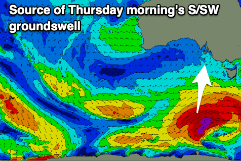
Moving into Thursday, and our next strong pulse of S/SW groundswell is expected, generated by a polar front that's south-southwest of Western Australia. This front is due to form into a significant polar storm this evening, with a fetch of severe-gale to storm-force SW winds firing up through our southern swell window, projecting towards Tasmania.
This will then be followed by secondary fronts, generating additional fetches of severe-gale SW winds in our southern swell window, south-west of Tasmania. This activity is thanks to a strong node of the Long Wave Trough forming east of us, steering and strengthening polar frontal systems up towards Tasmania and New Zealand.
Thursday's swell should come in around 5-6ft across Middleton during the morning, with the Mid Coast seeing 1ft sets but with light to moderate S/SW winds. The Victor region will likely see early light W/NW winds, but be workable regardless with the strength of the swell.
Similar light S/SW winds are due into Friday with an outside chance for early W/NW winds and Thursday's swell will be on the ease.

Later in the day and Saturday morning, some new reinforcing S/SW groundswell is due, generated by the secondary frontal activity behind the initial storm-force fetch. This should maintain 3-5ft sets across Middleton but with tiny surf across the Mid Coast, easing into Saturday afternoon.
Conditions look to become cleaner for the South Coast on Saturday with a light NE offshore wind, similar Sunday with what looks to be the next strong pulse of S/SW groundswell energy.
The source will again be strengthening polar frontal activity to the south of the country late week, with it likely to come in around 4-5ft. More on this Wednesday.