Persistent onshore winds down South with lots of swell

South Australian Forecast by Craig Brokensha (issued Friday April 5th)
Best Days: Keen surfers tomorrow morning and Sunday morning, South Coast Monday morning, Mid Coast for the keen Tuesday morning
Features of the Forecast (tl;dr)
- Mod-large pulse of S/SW groundswell for Sat PM with light-moderate S/SE winds, freshening into the PM
- Easing swell Sun with moderate S/SW winds, freshening later
- Easing swell Mon with W/NW winds, tending S/SW into the PM
- Moderate + sized S/SW swell Tue with S/SW winds (S/SE early on the Mid)
- Easing surf Wed with moderate S/SW winds (S/SE early on the Mid)
- Mod-large S/SW groundswell for Thu, peaking in the PM
- Mod-fresh S/SW winds Thu, similar Fri as the swell easing
Recap
Bumpy conditions across the South Coast yesterday with swell in the 3ft range, bigger this morning with a fresh pulse of mid-period S/SW swell to 4ft under E/NE winds. Conditions were lumpy and a bit all over the place (as expected) but OK for the keen.
The Mid Coast held an infrequent 1-1.5ft on the favourable parts of the tide yesterday, back to 1ft today.
This weekend and next week (Apr 6 - 12)
This morning's S/SW swell is due to ease into tomorrow morning, while into the afternoon, a strong new pulse of S/SW groundswell is due.
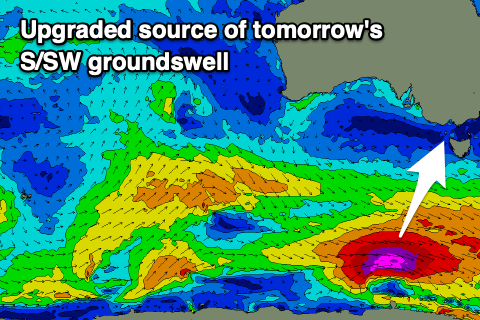
Sets to 3ft are due across Middleton early, while the groundswell for the afternoon has been generated by a great fetch of pre-frontal gale to severe-gale W/NW winds at the head of a deepening polar low. Storm-force winds developed at the core of the low, though late in our swell window, and with this we're got an upgrade in the size due later tomorrow.
The South Coast should reach 4-6ft on dark, then ease back from 4ft+ on Sunday morning, while the Mid Coast will be tiny.
Winds won't be great, but doable tomorrow morning for the keen on the South Coast with a light to moderate S/SE breeze, freshening into the afternoon as the new swell kicks.
Sunday looks to remain average but doable with a moderate S/SW breeze that doesn't look to freshen until later in the day.
Monday is looking fun with easing 3ft sets under a morning W/NW breeze that will then shift gusty S/SW into the afternoon.
This change will be linked to our next swell generating system moving in, under the state. That being a healthy fetch of strong to near-gale-force W/NW tending W winds forming within a frontal system that will form east of the Heard Island region today.
A moderate sized + pulse of mid-period SW swell is due Tuesday, coming in at 4-5ft across Middleton, with the Mid Coast likely to see 1-1.5ft sets on the favourable parts of the tide.
Winds will unfortunately remain moderate to fresh from the S/SW during Tuesday, possibly S/SE early on the Mid Coast, lighter into Wednesday as the swell eases.
For the rest of the week and next weekend, further pulses of moderate to large S/SW groundswell are due as a series of strong polar fronts fire up to the south-west of Tasmania, under the influence of a strong node of the Long Wave Trough moving across the southern Tasman Sea.

The first pulse of S/SW groundswell is due Thursday, peaking into the afternoon, likely to 4-6ft across Middleton into the afternoon, easing Friday. The Mid Coast looks to be only 0.5-1ft with this more southerly swell.
We'll be on the backside of the all the frontal activity which means we'll be under a persistent S/SW flow, creating bumpy conditions throughout.
More southerly winds with plenty more S/SW swell is due next Sunday/early the following week, but we'll go over this in more detail Monday. Have a great weekend!
Comments
Autumn is the best time of year to surf to surf in SA they say....
South East wind that continues to blow it's guts out: "Hold my beer"