Indonesia/Maldives forecast May 7

Indian Ocean Basin analysis by Craig Brokensha (issued Tuesday 7th May)
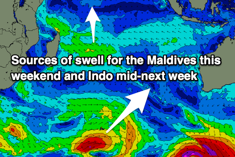
This week through next (May 8 - 17)
Our large pulse of SW groundswell came in right on cue across all regions over the weekend and into yesterday with pumping surf reported far and wide.
Since, the size has been on a slow decline and this will continuing into tomorrow, further Thursday morning.
Our inconsistent pulse of mid-period SW swell for later in the day Thursday and Friday is still on track, generated by a broad but not overly strong frontal progression that fired up to the south-east of South Africa late last week.
It looks inconsistent and moderate in size, with the swell then tailing off slowly through the weekend and into early early week.
The next noticeable increase in size is due the following Tuesday afternoon/Wednesday, with a small-moderate sized mid-period S/SW swell arrives. The source is a small, tight polar low with a fetch of severe-gale W/SW gales not really making much head-way up into the Indian Ocean.
Behind this though, mid-latitude frontal activity firing up towards Western Australia will be followed closely by some more significant polar storms, generating some larger groundswell into the end of the week.
The Maldives are seeing easing levels of S’ly groundswell with steady, small amounts of SE trade-swell, and the reinforcing pulse of strong S’ly energy for tomorrow is on track.
This looks moderate + in size and should peak through the day before easing into Thursday.
Otherwise, a strengthening fetch of SE trades just east of Madagascar over the coming days looks to generate some mid-period S’ly swell for Friday and the weekend, easing slowly into the next week.
We look to then see a slightly stronger pulse of SE trade-swell through next week as winds strengthen out of the west.
Eastern Indonesia:
Slowly easing swell tomorrow, further into Thursday morning.
Inconsistent, moderate sized, mid-period SW swell building late Thursday, peaking Friday to 4-5ft.
Small-moderate sized S/SW swell building Tuesday, peaking Wednesday to 3-5ft across exposed breaks
Moderate-large S/SW groundswell likely late week to the 6ft range.
Moderate to fresh E/SE trades, variable each morning.
Uluwatu 16-day Forecast Graph/WAMs
Western Indonesia/Mentawais/South Sumatra:
Easing S/SW groundswell tomorrow.
Moderate sized mid-period S/SW swell building Thursday to 4-5ft+, easing from a similar size Friday morning.
Moderate sized, inconsistent S/SW swell building later Tuesday, peaking Wednesday to 3-5ft.
Moderate-large S/SW groundswell likely late week to the 5-6ft range.
Variable winds.
Mentawai 16-day Forecast Graph/WAMs
Maldives:
SE trade-swell to 3ft this week.
New S’ly groundswell tomorrow to 4-6ft across the southern atolls, easing slowly Thursday.
Moderate sized S’ly trade-swell building Friday, reaching 3-4ft across the southern atolls on the weekend, easing a touch into next week.
SE trade-swell muscling up a little through next week to 4ft across open locations.
Moderate to fresh W/SW-W winds, tending W’ly on the weekend and strengthening through next week.
Comments
Latest notes are live.