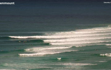
Make the most of Thursday, as we’ve got northerlies on the menu for Friday.
Primary tabs
/reports/forecaster-notes/south-east-queensland-northern-new-south-wales/2024/02/21/rinse-and-repeat
thermalben
Wednesday, 21 February 2024

/reports/forecaster-notes/south-east-queensland-northern-new-south-wales/2024/02/19/more-fun-trade
thermalben
Monday, 19 February 2024
Our recent source of trade swell is expected to muscle up a little over the coming days.
/reports/forecaster-notes/south-east-queensland-northern-new-south-wales/2024/02/16/ely-swell-keeps
freeride76
Friday, 16 February 2024
High pressure belt remains strong with cells lined up to enter the Tasman. A monsoonal low in the Gulf of Carpenteria is generating a long cloud band down the east coast. A long, broad E’ly tradewind fetch extends from the Coral Sea into the South Pacific with the tail of the fetch in Tahitian longitudes.
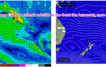
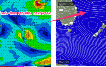
/reports/forecaster-notes/south-east-queensland-northern-new-south-wales/2024/02/14/e-swell-rebuilds
freeride76
Wednesday, 14 February 2024
Multiple cells of reinforcing high pressure then one by one move into the Tasman, maintaining a weak ridge up the NSW Coast and a deep E’ly flow through the South Pacific and Eastern Coral Sea, with resulting E’ly swells favouring the sub-tropics for size, with a rebuild in size expected later this week.
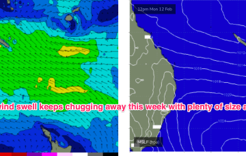
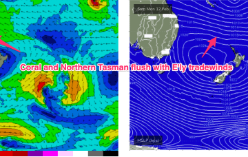
/reports/forecaster-notes/south-east-queensland-northern-new-south-wales/2024/02/12/plenty-ely-swell
freeride76
Monday, 12 February 2024
E’ly tradewind swell and plenty of it this week, with quality an issue in the short run.
/reports/forecaster-notes/south-east-queensland-northern-new-south-wales/2024/02/09/extended-run
freeride76
Friday, 9 February 2024
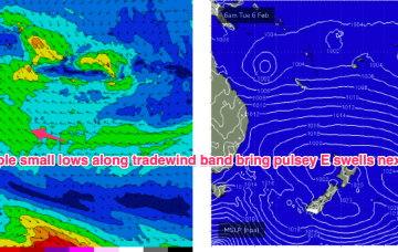
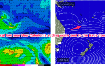
The E’ly-SE’ly fetch gets reinforced later Sat by a new high pressure ridge squeezing up against a tropical low hovering NW of New Caledonia so we should see surf start to build again through Sun, again, tidally affected by the big new moon tidal amplitudes.
/reports/forecaster-notes/south-east-queensland-northern-new-south-wales/2024/02/07/days-and-days
thermalben
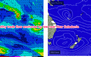
Wednesday, 7 February 2024
The surf outlook for SE Qld and Northern NSW is relatively straightforward, all thanks to an anchored ridge across the Northern Tasman Sea.
/reports/forecaster-notes/south-east-queensland-northern-new-south-wales/2024/02/05/extended-trade
freeride76
Monday, 5 February 2024
A semi-stationary area of low pressure in the Coral Sea is anchoring a broad trade-wind flow with an extended tradeswell event ahead.
/reports/forecaster-notes/south-east-queensland-northern-new-south-wales/2024/02/02/long-period-s
freeride76
Friday, 2 February 2024
Common to all major models is a robust tradewind flow through the Coral and Northern Tasman which will favour the sub-tropics for size into the weekend 10-11/2 and hold plenty of pulsey E’ly tradewind swell through most of next week from Tues.
/reports/forecaster-notes/south-east-queensland-northern-new-south-wales/2024/01/31/some-clean-bits
freeride76
Wednesday, 31 January 2024
The monsoon remains active with a small sub-tropical low moving E off the QLD coast where it may undergo further development In the Coral Sea in the medium term. A typical summer tradewind band cradles this low next week with plenty of E quadrant swell expected, favouring the sub-tropics for size.