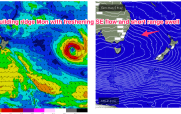
Monster high pressure has barely budged since Wed, maintaining a S-SE flow right up the Eastern Seaboard, with a coastal trough ensuring plenty of unstable, rainy weather.
Primary tabs
/reports/forecaster-notes/sydney-hunter-illawarra/2024/05/03/periods-lighter-winds-in-the-rain-se
freeride76
Friday, 3 May 2024
/reports/forecaster-notes/sydney-hunter-illawarra/2024/05/01/extended-run-s-se-winds-still-ahead
freeride76
Wednesday, 1 May 2024
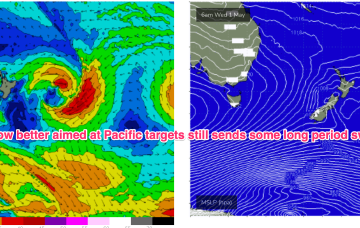
A storm force polar low is better aimed at Pacific targets but we’ll still see some long period S groundswell from it this weekend, with the proviso that S’ly winds will remain persistent.
/reports/forecaster-notes/sydney-hunter-illawarra/2024/04/29/stubborn-high-in-the-bight-brings-se
freeride76
Monday, 29 April 2024
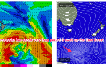
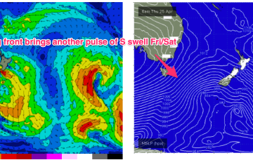
Later polar fronts in the far southern/central Tasman remain strong and although better aimed at Pacific targets we’ll still see some significant sideband S’ly energy from them.
/reports/forecaster-notes/sydney-hunter-illawarra/2024/04/26/improving-conditions-over-the-weekend
freeride76
Friday, 26 April 2024
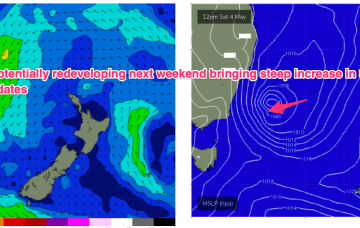
Things get interesting/dynamic from Tues. At issue is a trough and potential surface low in advance of a major high pressure ridge.
/reports/forecaster-notes/sydney-hunter-illawarra/2024/04/24/sly-pulses-ahead-improving-conditions
freeride76
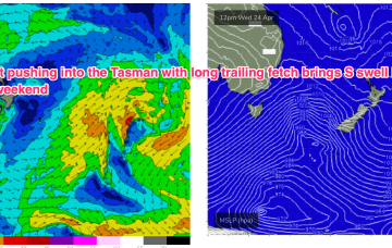
Wednesday, 24 April 2024
Friday looks solid as a range of mid period and longer period S swell trains generated by the proximate and deep fetches make landfall.
/reports/forecaster-notes/sydney-hunter-illawarra/2024/04/22/generally-downgraded-outlook-week-the
freeride76
Monday, 22 April 2024
Some frontal activity to the south is poorly positioned and aligned but we will see a stronger frontal intrusion into the Tasman later this week, although not with an accompanying Tasman low as suggested on Friday.
/reports/forecaster-notes/sydney-hunter-illawarra/2024/04/19/ordinary-weekend-some-quality-conditions
freeride76
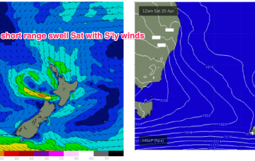
Friday, 19 April 2024
As the low moves offshore Fri odds are firming we’ll see a major S swell develop as gales develop on the western flank of the low, proximate to the NSW coast.

/reports/forecaster-notes/sydney-hunter-illawarra/2024/04/17/clean-and-easing-in-the-short-run-few
freeride76
Wednesday, 17 April 2024
Plenty of action in the tropics and subtropics next week but we’ll see a quiet opening to the week for temperate NSW, with some model divergence for later next week.
/reports/forecaster-notes/sydney-hunter-illawarra/2024/04/15/nice-swell-combo-ahead-the-east-and
thermalben
Monday, 15 April 2024
Late afternoon, the leading edge of a new long period S’ly swell will make landfall, though we’re not expecting wave heights to peak until...
/reports/forecaster-notes/sydney-hunter-illawarra/2024/04/11/full-spectrum-autumn-pattern-provides
freeride76
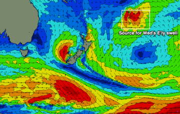
Friday, 12 April 2024
We’ve still got an intense Tasman low in the picture sending plenty of swell our way, located now off the west coast of the South Island, with a large slow moving high SW of WA and powerful fronts under the SE of the continent.
