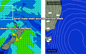
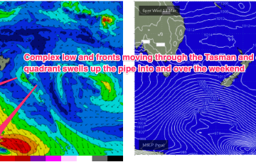
The NZ high has generated a useful fetch of tradewinds in the eastern swell window, which has maintained E’ly swells in the sub-tropics, E/NE in temperate regions. That trade fetch breaks down in the short term before rebuilding again at more Northern latitudes. We’ll see some frontal activity over the weekend before another strong, blocking high sets up a ridge next week.
Primary tabs
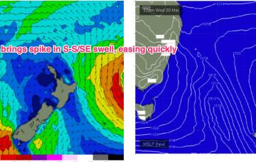
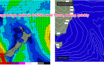
/reports/forecaster-notes/sydney-hunter-illawarra/2024/03/19/spike-in-windy-s-swell-then-easing-trend
freeride76
Wednesday, 20 March 2024
/reports/forecaster-notes/sydney-hunter-illawarra/2024/03/18/fun-mixed-bag-week-summer-pattern-slowly
freeride76
Monday, 18 March 2024
We’ll see this pattern disrupted mid-week by an aggressive trough which brings S winds and swell before the next high slowly resets the trade pattern, this time further north in the Coral Sea.
/reports/forecaster-notes/sydney-hunter-illawarra/2024/03/15/plenty-swell-just-gotta-work-around-the
thermalben
Friday, 15 March 2024
Today’s onshore pattern will contract to the North Coast on Saturday, and Sunday looks very interesting with a new long period S/SE groundswell.
/reports/forecaster-notes/sydney-hunter-illawarra/2024/03/12/very-busy-outlook-ahead-windows-real
freeride76
Wednesday, 13 March 2024
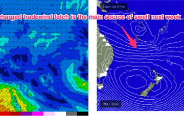
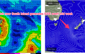
We’ve still got a broad trade wind flow in the Coral Sea, extending out into the South Pacific and anchored head and tail by low pressure along the monsoon trough. That’s producing heavy swells in the sub-tropics (full blown Point surf equivalent to cyclone swells) with a fair amount filtering down to temperate NSW.
/reports/forecaster-notes/sydney-hunter-illawarra/2024/03/11/dual-swells-provide-the-goods-week
thermalben
Monday, 11 March 2024
Lots of swell to look forward to this week, and winds should remain light under a weak local synoptic pattern.
/reports/forecaster-notes/sydney-hunter-illawarra/2024/03/08/fun-week-ene-trade-swell-some-small-s
freeride76
Friday, 8 March 2024
There was a nice, lingering tail to the S swell event but we’re now entrenched in a classic late Summer pattern with strong high pressure moving into the Tasman, setting up a downstream blocking pattern and very healthy tradewind fetch through the Coral Sea, extending E into the South Pacific and south into the Northern Tasman.
/reports/forecaster-notes/sydney-hunter-illawarra/2024/03/05/easing-s-swells-nice-run-ene-swell-ahead
freeride76
Wednesday, 6 March 2024
Classic late Summer pattern next week with high pressure straddling New Zealand, a monsoon trough strung across Northern Australia extending into the South Pacific and a long, broad tradewind fetch between the two broadscale atmospheric features. The fetch is so broad and long that we’ll see quite an energetic E/NE swell propagate down the NSW Coast.
/reports/forecaster-notes/sydney-hunter-illawarra/2024/03/04/lots-sizey-s-swell-week-easing-thurs
freeride76
Monday, 4 March 2024
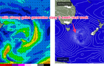
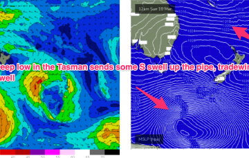
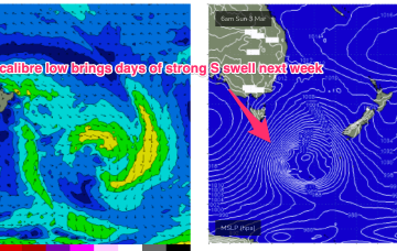
We currently have a deep, winter-calibre double-headed low traversing the lower Tasman. Current ASCAT (satellite windspeed) passes show a long fetch of severe gales in the southern swell window and wave buoys are all in an aggressive upwards curve as strong S swells build along the Southern NSW Coastline.
/reports/forecaster-notes/sydney-hunter-illawarra/2024/02/29/winter-calibre-low-brings-days-strong-s
freeride76
Friday, 1 March 2024
Models are holding steady on a winter calibre low tracking well to the south- south-east of Tasmania during Sun and traversing the far Southern Tasman through Mon.
/reports/forecaster-notes/sydney-hunter-illawarra/2024/02/28/sizey-s-swell-the-radar-next-week-strong
freeride76
Wednesday, 28 February 2024
Some quiet days then follow before a much more robust front and low enter the lower Tasman late in the weekend driving some sizey S swell up the coast early next week.