Small surf persists, with a bit more swell due late next week

Western Australian Surf Forecast by Craig Brokensha (issued Friday November 3rd)
Best Days: South West magnets today, tomorrow morning and early Sunday, Wednesday morning in the South West, protected spots next Saturday, next Sunday morning
Features of the Forecast (tl;dr)
- Small levels of background swell tomorrow, with a slight kick through Sun (peaking PM)
- Early gusty E/SE-E/NE winds tomorrow, holding all day to the north, with sea breezes to the south
- Early fresh E/SE winds Sun AM, tending SE then SW
- Small Mon with strong S/SE winds, tending SW to the north in the PM
- Strong S winds Tue with a building mid-period SW swell, peaking Wed AM with E/SE-SE tending SW winds
- Smaller Thu with S/SW winds
- Mod-large mid-period SW swell for Fri with strengthening W tending SW winds
- Easing swell next Sat with strong S/SE winds
- Smaller Sun with E/SE tending S/SW winds
Recap
Tiny surf to the north and small leftover waves across the South West yesterday, a touch stronger today and to 3ft on the magnets but with strong offshore winds. The winds are starting to ease and will give into mid-afternoon sea breezes.
This weekend and next week (Nov 4 - 10)
Small surf will continue tomorrow, with background energy due to maintain slow 3ft sets across the South West magnets, tiny to the north.
Gusty E/NE offshore winds are due tomorrow morning again, holding offshore all day to the north which will bring in the heat, while mid-afternoon sea breezes are due across the South West. These winds will be feeding into a heat low which looks to start moving east on Sunday. This will bring early fresh E/SE-E winds, easing and then tending SE before shifting S/SW as a the low shifts south-east.
A small lift in mid-period SW swell is due on Sunday with it building to 3-5ft across the magnets through the day (tiny to the north), before easing Monday.
Strong S/SE winds are then due in the wake of the low on Monday, shifting SW to the north and kicking up some low quality windswell that will ease Tuesday with persistent gusty S'ly winds.
Later in the day Tuesday but more so Wednesday, some new mid-period swell energy is due with a bit more size than we're currently seeing.
It will again be generated by a weak flurry of polar frontal activity with a train of strong W/SW winds moving through our swell window over the weekend.
This should produce a moderate sized spike of swell for Wednesday morning to 3-5ft across the South West magnets, tiny to the north and with better E/SE morning winds ahead of sea breezes.
The swell will ease Thursday as winds shift back onshore thanks to another trough clipping us, while strengthening W tending SW winds are due on Friday as a stronger front projects up into the state.
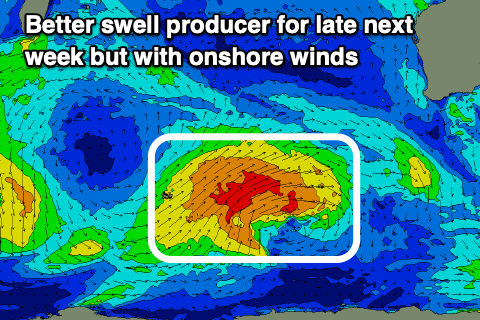
This front will form on the backside of a healthier polar low that will generate some larger swell for the end of the week and weekend.
The low is forecast to form around the Heard Island region earlier next week, projecting a slow moving fetch of strong W/SW-SW winds towards us. The front moving in on Friday will develop on the backside of the low, with a mix of mid-period swell energy due to build Friday, reaching 6ft+ across the South West, 2ft in Mandurah and Perth but with those strong onshore winds.
The front will clear east next weekend which should bring improving winds as the swell eases. Saturday still looks average with strong S/SE breezes, better Sunday and E/SE but with smaller, fading surf.
Beyond this the outlook remains slow unfortunately. Have a great weekend!