Nice round of long period south swell ahead

Sydney Hunter Illawarra Surf Forecast by Ben Matson (issued Mon Dec 11)
Features of the Forecast (tl;dr)
- Nice S'ly groundswell due late Tues (earlier South Coast), peaking Wed.. light/var AM winds, mod N/NE for the PM
- Easing S'ly swell Thurs with early light winds
- Small weak surf over the weekend
- Chance for an E'ly swell mid-next week
Recap
Small weak waves over the last few days, with the direction initially out of the NE on Saturday before tending S'ly on Sunday, then back to the NE this morning. Winds have been from the same direction, no major strength though enough to lower surface quality. Size hasn't amounted to much more than 2ft at exposed spots, it's only been low quality windswell each day.
This week (Dec 12 - 15)
Tuesday will start out small and weak, similar to today though light winds should allow for reasonable conditions.
From about lunchtime onwards (South Coast) and late afternoon across the Sydney region, we'll be on high alert for the leading edge of a decent long period southerly groundswell, generated by a strong and broad, if somewhat off-axis frontal system currently projecting from the far eastern Indian Ocean into the lower Tasman Sea (see below).
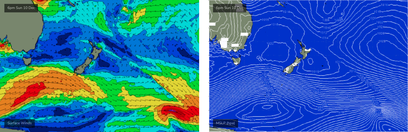
This swell will show best on Wednesday morning, and it'll display a classic spread of size between southern corners (1-2ft), most open beaches (3ft+) and south facing beaches (4-5ft). Becaude of the healthy percentage of energy in the upper peeriod bands (15-16 seconds), we should also see bigger sets pushing 6ft+ at the handful of reliable deepwater reefbreaks that effectively accentuate surf size. We'll then see size ease slowly into the afternoon.
But just to reiterate, any time Tuesday afternoon (South Coast) and late arvo/evening (Sydney) could see some step-ladder sets from the south as the new energy arrives. So be ready to pounce.
Wednesday's winds look great early with a light variable flow, we'll then see light to moderate N/NE winds throughout the day.
Wednesday's south swell will than taper off into Thursday under a similar wind regime, leaving us with small residual leftovers for Friday morning and a shallow southerly wind change that won't offer anything really worthwhile.
A minor long period southerly swell may glance the coast through the afternoon but no major size is expected, perhaps some stray 2ft sets at south facing beaches if we're luckly (the swell source is very much off axis, short in length, and distant in proximity).
So, it's late Tuesday or (more reliably) Wednesday morning for the win this week.
This weekend (Dec 16 - 17)
A lot of lingering troughiness adjacent the coastal margin later this week isn't expected to coalesce into any kind of decent swell generating system.
Unfortunatelty, this means we're expecting generally small swells from distant and/or weak sources both days.
A shallow southerly change is expected to move across the Southern NSW coast on Saturday, pushing north into Sunday but lingering across the region north from Sydney early morning.
I'll have more specifics on Wednesday but for now it's not looking very promising.
Next week (Dec 18 onwards)
Persistant troughiness will maintain small weak local swell sources early next week but there's presently no indication for any major size.
There's also some mild promise for trade sources to firm up later in the outlook period but these are usually a peripheral source of swell for Southern NSW; our coast requires more substantial synoptics or at least a weather system positioned more closely to the coast.
That being said, there is some potential activity in the Tasman Sea on the cards for the middle of next week that could produce a more robust easterly swell (around the 21st), but it's too far out to have any confidence. I'll have more on that in Wednesday's update.
Comments
Anyone seen sign of the S swell yet?
Heard reports of it south of Batemans. Wouldn't expect anything until very late.
Yeah, 1300 BB buoy shows the forerunners I likely surfed, a consistent 2ft maybe a smidge bigger, exposed beachie.
I think it will be a bit undersized for the south coast, size should be better for the forecast zone once it fills in (in the morning).
Cheers Belly!
Very strong across Vicco/SA/Tas coasts today as well (doesn't assist so much with NSW timing, but does help to corroborate overall characteristics).
Thanks. Hopefully get something before dark.
Water temperatures inshore are about as warm as it gets. 22°C I'd say, warmest I've felt this time of year and only gets a couple of °C more when at its hottest through summer/early autumn.
Interesting Craig. Been swimming/body surfing most days, given the small conditions, and the water last week was as cold as it has been since winter. Last Wednesday at a Sydney beach was way down. Since then it hasn’t been warm, now up at Cennie Coast, and yesterday was a mix of cool and warmer water, but still occasionally bracing. Nowhere near 22, at which point I find it overly warm and not at all refreshing.
Will have to check back later with today’s temps. Are you talking Sydney beaches?
Yeah Manly, cooking. Rest of the Northern Beaches are similar.
did not need a steamer this morning. waves cooking, I was cooking, we were all cooking. Not too busy iether.
Yep just got out. Still warm as.
20s @ 2pm in Batemans..
Sydney portauthority buoy atm showing max 1.4m @ 12sec from the south.
Late one could be fun.... somewhere.
Jimbles are cruising with the currents, so a long sleave rashy is worthwhile, if your paddling out in a rip with weed & flotsam.
https://australian.museum/learn/animals/jellyfish/jimble/
Not be be confused by this one...
https://australian.museum/blog/amri-news/a-jellyfish-out-of-the-box/
Pretty bog standard South swell out there
600m close out bombs at my local