Back to back S'ly groundswell pulses

Sydney, Hunter and Illawarra Surf Forecast by Guy Dixon (issued Wednesday 27th July)
Best Days: Friday, Sunday and Monday
Recap:
It’s been a great couple of days across the NSW coast with a strong southerly groundswell building to around 5-6ft+ on Monday (more so 6-8ft along the Hunter), before easing to around 3-4ft on Tuesday, further to around 1-2ft today.
Conditions remained clean each day with the exception of a brief period of onshore breezes near Sydney on Tuesday.
This week (Thursday 28th - Friday 29th):
The southern swell window will be the main contributor this coming week with frontal activity looking to generate a series of good pulses.
First off, a frontal progression has been steering a small but strong westerly fetch across the Southern Ocean overnight, followed by weaker by more favourably aligned southwesterly trailing fetches. These winds look slow moving, weakening with time. As the impacts from this modest fetch build across south facing beaches on Thursday afternoon to around 2ft to occasionally 3ft, a second better swell source should also become apparent soon after.
The first hints of this new groundswell are likely to move in under the cover of darkness on Thursday evening, however Friday morning should see good strong southerly swell breaking across exposed south facing locations.
The system responsible is on track to sweep south of Tasmania overnight tonight, steering increasing 45-55kt west/southwesterly core winds up over southern and central parts of the Tasman Sea. I wouldn’t say this system is projecting in a captured motion up through the Tasman, but I wouldn’t play it down by saying it’s moving in a zonal motion either.
The only limiting factor of this swell source would be the rapid motion across the swell window, with only a small and insignificant southwesterly fetch located further south to back it up.
Nevertheless, strong sets should be on offer in the 4-6ft range on Friday morning at south facing beaches, larger across the Hunter, easing throughout the afternoon.
Conditions should remain clean for the majority of each day, becoming light each afternoon which may allow for a weak, localised sea breeze to develop, not enough to worry about.
This weekend (Saturday 30th - Sunday 31st):
The next major fetch isn’t due to move into the southern swell window until Friday afternoon, but broad, lingering southwesterly fetches should maintain a small amount of energy on Saturday, preventing it from dropping too quickly and maintaining options in the 2-3ft range.
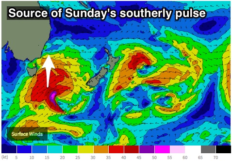 A broad and well consolidated fetch looks to move south of Tassie into the evening of Friday, although with a smaller and less intense core fetch. Although moving in an easterly direction, it’s trajectory looks slower, with southwesterly breezes encompassing a larger area. Having said that, the sea-state may not be as activated as the previous swell.
Having considered all of these factors, south facing beaches may see the first hints of size late on Saturday afternoon (more so South Coast), more so into Sunday morning where sets should break in the 4-6ft range, larger across the Hunter before easing during the later afternoon.
Breezes should remain offshore each morning, with a light seabreeze developing on Saturday. Sunday may see a very light onshore breeze, but nothing too serious.
Next week (Monday 1st onward):
A slim and elongated southwesterly fetch move into the swell window soon after, not to mention residual energy from lingering breezes over the Tasman. The resultant swell isn’t looking like anything groundbreaking, but should maintain a small amount of energy into next week, with options in the 3-4ft range on Monday, smaller on Tuesday.
Comments
Sounds good bring it on...............
have to fix the tale with uv rising on sat morning and smash it again
Unexpected arrival of a strong pulse this morning Ben, seems to be in the 3-4 range and looks like groundswell.
Wasn't expecting this so early!
Sorry mate, missed this comment - was on the road all day yesterday. Will have to check hindcast data anmd chat with the lads to see what happened (I'm doing the forecaster notes this arvo).
Solid sets this AM - how's this long closeout line!
Nice lines at Shark Island.