Plenty of strong south swell from Sunday onwards

Sydney, Hunter and Illawarra Surf Forecast by Ben Matson (issued Friday 22nd July)
Best Days: Sunday: building S'ly swell with good winds. Monday: strong S'ly swell with good winds. Tuesday/Wednesday: easing S'ly swell with good winds. Wed may see a fresh, rebuilding S'ly swell. Thurs/Fri/Sat: stronger S'ly swells with good winds.
Recap: Thursday saw a mix of E/SE swell and late building S’ly groundswell, with sets around 3ft at exposed beaches throughout the day (smaller at remaining beaches). Both of these swells faded overnight and have continued a downwards trend today, and yesterday’s light variable winds have freshened from the N/NW quadrant today.
This weekend (Saturday 23rd - Sunday 24th):
The weekend’s on track to deliver two completely different days of waves, but with fresh offshore winds the entire time.
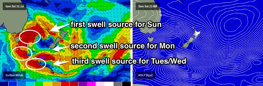
Saturday looks like a write-off in general. A broad, multi-centered low pressure system will develop across the entire Tasman Sea basin early Saturday morning, however it looks like our south swell window won’t become active until very late in the day. As such, we’re not likely to see much of an increase - if any - until Sunday from this source.
Our automated forecast system is currently suggesting 2-3ft surf at south facing beaches however I think this is a dramatic overcall by the computer models, as the primary swell direction is W/SW (seems to be an unusual anomaly, probably related to the strength and duration of the westerly breeze in close to the mainland). A tiny unrelated long period south swell is modelled to push up the coast though I don’t think it’ll have enough size to produce anything worthwhile - maybe a lazy foot or two at exposed south swell magnets at best, and flat at most beaches. As such I would be very cautious about your expectations on Saturday.
W/SW gales will then exit eastern Bass Strait on Saturday afternoon as the system pushes across the region, and we’ll see a couple of fetches fire up concurrently - we should see a decent short range swell build from this first fetch on Sunday (poorly aligned, but broad and strong enough to facilitate a decent spread back into the mainland), followed by a very late arrival of better S’ly groundswell from a secondary front developing S/SE of Tasmania on Saturday afternoon (showing properly across most coasts on Monday).
A third fetch related to an embedded polar low within the broad system - much further south - will produce another south swell for Tuesday.
As such, Sunday should build rapidly to be somewhere in the 3-4ft+ range at south facing beaches by the afternoon. Wave heights may be a little undersized early morning, and beaches not completely open to the south will see smaller surf as per usual, however the Hunter (and offshore bombies further south) should pick up a few bigger sets at times after lunch as the swell builds in size.
I wouldn't be surprised to see occasional 4-6ft sets across the Northern Hunter region late in the day.
Surface conditions look nice and clean on Sunday with moderate W’ly winds tending light W/NW into the afternoon. So the afternoon is on target for a great round of surf, if your local enjoys southerly groundswells.
Next week (Monday 25th onward):
The secondary and tertiary fronts (and/or polar lows) associated with this system look like they’ll deliver the juiciest swell from this system, arriving early Monday (possibly late Sunday in the Far South).
The first fetch - S/SE of Tasmania late Saturday - is modelled to slingshot around the primary low into Sunday, aimed nicely within our swell window. The leading edge of this swell is due overnight on the South Coast, reaching the Sydney region just before dawn and likely peaking before lunchtime.
South facing beaches should see solid sets in the 4-5ft+ range throughout Monday, with bigger waves across the Hunter region (6ft+) and conditions are expected to be clean with moderate W/NW tending fresh W’ly winds. Once again, locations not completely open to the south will be much smaller in size.
The third polar low will track SE over the weekend but then remain slow moving off the ice shelf for a day or so, which will set up a smaller but useful S/SE through Tuesday and Wednesday, whilst Monday’s S’ly groundswell eases back in size. Both days are looking nice and clean with light to moderate offshore winds; wave heights will again be biggest at south facing beaches, easing from 3-5ft early Tuesday to 2-3ft by Wednesday and with the usual caveats for other locations (bigger in the Hunter, smaller at beaches not open to the south).
Looking further ahead and another extended period of strong frontal activity is expected from Tuesday onwards. Current model guidance has a predominantly zonal pattern at first (which will cap wave heights across Southern NSW, in and around a mid-week pulse of new S'ly energy) followed by a slightly stronger, more meridional (north-south) flow from late Wednesday onwards that could generate a much larger southerly swell for Thursday, Friday and Saturday.
Either way, we’ve got no shortage of southerly swell on tap so it’s looking like a very active period ahead for south facing coasts.
More on this in Monday’s update. Have a great weekend!
Comments
How d'ya like your south swell?
Looks like we've got half a dozen of 'em at least on the way for the next week. Probably more!
Stunning morning in Sydney. Shame about the lack of surf! A few tiny lines though.
Life sure is grand!
Heading to the Hunter early tomorrow for an early. How much swell do you reckon will be in the water from 6.30 til 10am, Ben?
Jeez, how specific's that kinda request?
This belongs in the vicco comment thread. That's gold
Haha
Find out in the morning.Flat as tac when i looked at sunset.
Newcastle is pulling in some strong lines this morning, with sets in the 3-5ft range. Much bigger than the greater Sydney region too, which is less consistent and only 2-3ft.
Typical size range at Bondi this morning, somewhere in the 2-3ft range.
Keep your eyes on next weekend Ben. Thinking a little trip may be in order. Latest charts have potential, although possibly pushing out later to Saturday Sunday and maybe Monday. Will have to work out whether to have the Friday off or the Monday depending on forecast.
No major size increase at Bondi from this morning, as yet.
Newy! Not bad for the top of the tide.
Bigger 3-4ft sets on offer at Bondi this afternoon.
Decent section off the end bowl at the Island this morning. Not bad for a straight south swell.
Longy definitely had the bombs, local crew at it as usual