Large swells this period, cleanest as they ease

Southern Tasmanian Surf Forecast by Craig Brokensha (issued Monday November 13)
Best Days: Wednesday morning, Friday morning, early Saturday, Sunday morning, Monday
Features of the Forecast (tl;dr)
- Large SW groundswell building tomorrow, peaking in the PM with moderate W/SW tending strong SW-S/SW winds
- Easing swell Wed with variable N/NW tending E then late S winds
- Easing swell Thu with strong SW winds
- Smaller but fun Fri with NW tending W/SW winds
- Large S/SW groundswell building Sat with W/NW tending strong S winds
- Easing S/SW groundswell Sun with variable tending E/NE winds
Recap
Tiny, choppy surf to kick off the weekend, while a slight lift in inconsistent W/SW swell was seen yesterday with clean morning conditions.
Today our better, stronger SW swell is on the build with 2-3ft sets this morning under offshore winds and a further increase to 3-4ft is due this afternoon.

Chunky this afternoon but straight
This week and weekend (Nov 14 - 19)
We've got a very active forecast period ahead thanks to an overactive Southern Ocean storm track.
Today's smallest swell was generated by a healthy polar low that fired up over the weekend, but behind this we've seen a secondary system generating a significant fetch of severe-gale to storm-force W/SW winds.
This is a little stronger than forecast on Friday and we should see the SW groundswell from this source arriving tomorrow, building rapidly to a large on the sets 6ft into the afternoon across Clifton, easing back from 4ft+ on Wednesday morning.
Local winds are dicey and look to be out of the W/SW early, shifting SW and then S/SW while strengthening.
Wednesday will be cleaner with variable N/NW winds due ahead of E'ly sea breezes and a late S'ly change.
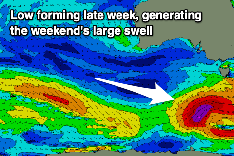
Thursday (onshore) and Friday look smaller, but as we move into the weekend, another large, significant pulse of S/SW groundswell is expected across the state, generated by another strong polar low firing up to our south-west.
This almost looks to be a 'bombing' low, dropping 24hPa within a 24 hour period with GFS on board with this scenario, while EC is weaker and only drops 20hPa or so.
Regardless we're set to see a strong polar low forming, generating a fetch of severe-gale to possibly storm-force SW winds in our southern swell window late week.
The swell will arrive Saturday, building rapidly into the afternoon/evening and reaching 6ft by dark but with S'ly winds in the wake of a morning change, with Sunday seeing easing surf from 5-6ft with variable tending E/NE winds.
So all in all a very active and large period of swell energy. Longer term is quieter but still active, though check back here on Wednesday.