A lovely mid-week pulse for the beachies

South-east Queensland and Northern NSW Forecast by Ben Matson (issued Mon April 15th)
Features of the Forecast (tl;dr)
- Nice mix of E'ly swell (all coasts) and S'ly swell (NNSW) on Wed with light winds most of the day (keep an eye out for the leading edge of E'ly pulse mid-late Tues in some areas)
- Easing swell combo Thurs with early light winds
Recap
Strong SE swells over the weekend maintained 4-6ft sets across Northern NSW on Saturday, though the southerly component in the swell direction limited size to 3ft across most of the Gold and Sunshine Coast (bigger at south swell magnets). Size then eased back a foot into Sunday and another foot into this morning, with most locations continuing to produce fun options - though size is starting to become a little on the small side north of the border now. Conditions have been generally clean through the mornings with light offshore winds ahead of weak afternoon sea breezes.
(Please note: FC Notes will be variable in delivery this week as Craig is on paternity leave and Steve is covering Margs)
This week (April 16 - 19)
Tuesday morning will be a little slow, as we’re going to be between swell events and there’s a risk of a developing northerly breeze (mainly along the Mid North Coast). Exposed south swell magnets south of the border should manage slow 2-3ft sets from the southern quadrant but it’ll be smaller elsewhere, and north of the border will be much smaller. Exposed locations in Northern NSW should have fun beachies though.
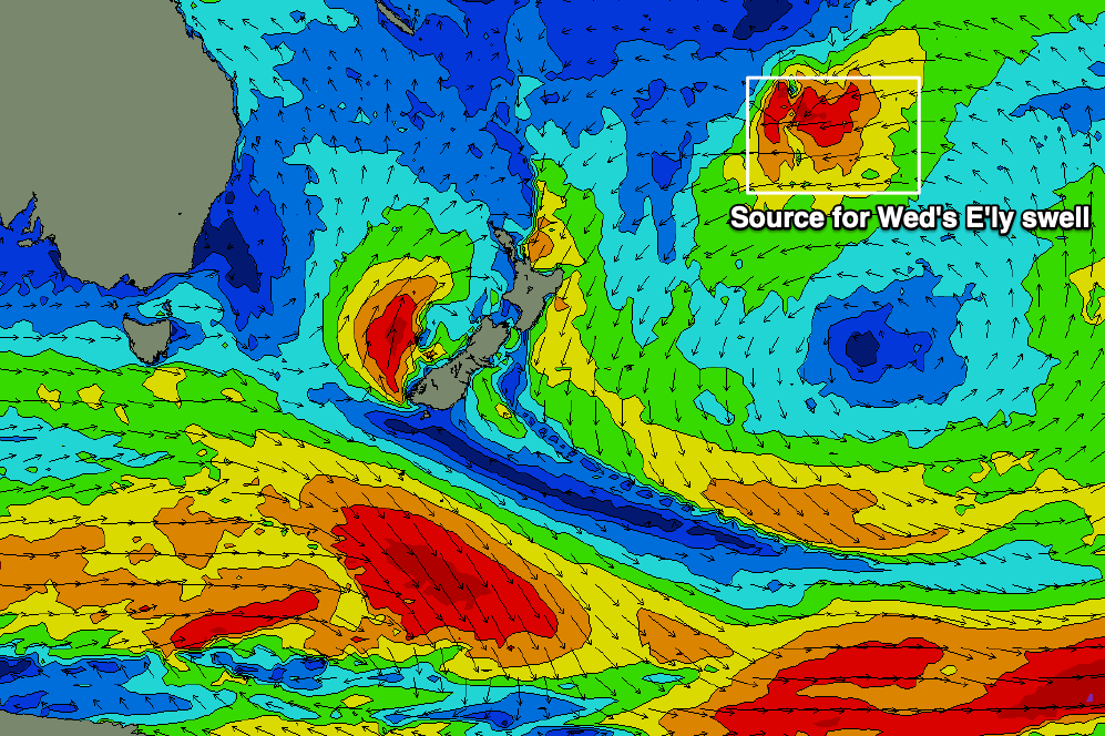
Mid to late afternoon, the leading edge of a new long period E’ly swell will make landfall, though we’re not expecting wave heights to peak until Wednesday. This swell was generated late last week from a sub tropical low positioned south of Tonga (see below), and we’re looking at some quality 3-4ft sets peaking across most open stretches, however there will be occasionally long breaks between the sets due to the distant swell source.
Also in the mix on Wednesday will be some long period southerly swell, generated by a strong frontal pushing south of Tasmania overnight, though it was downgraded a little in the latest model runs, so I have pulled back size estimates from Friday’s notes.
South facing beaches south of Byron should see 2-3ft+ sets, and may produce the odd bigger bomb when the swell trains merge together. We probably won't see much south swell north of the border, especially given the pre-existing easterly swel that'll be larger in size anyway.
Light variable winds and weak sea breezes are expected across most coasts on Wednesday so it’s well worth pencilling in a surf session.
Both swell sources will then trend down for the rest of the week, with light NW tending moderate N’ly winds Thursday giving way to fresh southerly winds on Friday as a weak front pushes up the coast. We’ll see decent workable options early Thursday before the wind picks up, but aim for a dawn session as the trend will be heading down. Friday doesn’t look much chop at this stage, just small leftovers across the semi-exposed points.
This weekend (April 20 - 21)
We’ve got a bit of an ordinary weekend ahead, especially given what’s been on offer in recent times.
A low developing off the Southern NSW Coast on Friday holds most of the new swell potential, as we’ll otherwise see minor energy from distant, flukey sources including some peripheral southerly swell from poorly aligned Southern Ocean fronts.
If Friday's low strengthens as modelled, Saturday will see bumpy 3-4ft surf building across south facing beaches in Northern NSW though they’ll be buffeted by freshening southerly winds.
Elsewhere it’ll be much smaller, including those locations in SE Qld that can handle southerly breezes.
Similar conditions are expected on Sunday with some local S/SE windswell coming into the mix as a ridge builds along the Qld coast.
I’ll refine the weekend outlook in more detail on Wednesday.
Next week (April 22 onwards)
Right now there’s nothing special on the cards for next week, with the storm track generally aligned outside of NSW’s swell window, and a ridge across the Qld coast (early in the week) being more meridionally aligned - that is, north/south - than is ideal.
As such we’re expecting low swells from peripheral sources - generally smallish mid-period south swells from the Southern Ocean, which will generally favour south swell magnets for the most size, and one or two bigger pulses within the mix.
Tuesday and Wednesday are on target for a decent push from this pattern (across Northern NSW, that is) with possible 3-4ft sets on offer, but we really need a few more days for things to firm up.
See you Wednesday!
Comments
Tweed buoy showing a jump in Tp to 14 seconds.. looks like the leading edge of the new E swell.
Yep, definite increase showing on Tweed beaches, bring on tomorrow. Hopefully winds play ball!
Damn solid and powerful on the open beaches this morning. Some impressive swell periods on the wave buoys too. I haven't been looking at the charts much this week so where'd this long range East swell come from?
I left a pretty image and a description in the notes above, Don.
Roll of the dice on the paddle outs this morn, either straight back out or 7mins of going for it with plenty of sets directly on the head, heap of push this about
shes not 2-4ft here pretty solid 5-6ft
Double overhead?
Double overhead?
Triple. @simba's kānaka.
Four max on the sets with plenty of push behind em
3-4ft here on the sets.
Yeah but not your average 3-4ft swell power. I got pushed down so hard just duck diving one set this morning.
Deffo some push with that period.
3-4ft sets here too, just did a drive by. Looks nice but pretty straight - best suited to the points though ironically they're the least suited to inconsistent long range swells (crowd wise).
3-4ft before or after dividing by 2?
2-3 GC beachie early for a couple hours. Pretty slow and not much power to it. Bit weird hearing the other reports, would have been nice.
yeah agree super slow and super straight on the GC beachies today... not alot of push either.....the state of the banks are pretty lousy, that might of been reducing the power somewhat...