Several strong swells inbound this week

South Australian Surf Forecast by Ben Matson (issued Monday April 22nd)
Features of the Forecast (tl;dr)
- Fun surf on the Mid Wed/Thurs
- Improving surf at Victor on Thurs
- Strong, sizeable swell with light winds at Victor on Fri
- Favourable conditions at Victor Sat/Sun with easing swells
Recap
The Mid’s been tiny for the last few days, and a small lift in size at the CdC buoy today hasn’t materialised into much surf. Wave heights eased from 3ft at Middleton on Saturday to 2ft on Sunday, before building from 2ft to 2-3ft today with the new swell. Both mornings over the weekend saw light winds early before S/SE breezes; today’s seen a more steady offshore breeze all day, with a weak onshore kicking in just in the last hour or so.
(Please note: FC Notes will be variable in delivery this week as Craig is on paternity leave)
This week (April 23 - 26)
A strong winteresque frontal progression will deliver plenty of waves throughout the state this week. However, associated onshore winds will deliver generally average surface conditions down south for the next two or three days.
The first front is due to push through mid afternoon on Tuesday, ahead of it we’ll see freshening NW winds with clean conditions at Victor as today’s swell slowly eases back in size, ahead of a late kick in new groundswell along with some local windswell.
A similar swell pattern will persist along the Mid Coast; initially small conditions through the morning with freshening NW winds will build into the afternoon, as we pick up new windswell trailing the front, plus the start of a new groundswell sequence - however there won’t be enough size (or wind strength) for a stormy. Expect low quality surf in the gulf on Tuesday.
Persistent onshore winds down south on Wednesday will maintain poor surface conditions as wave heights become quite strong, sourced from from polar latitudes, with Middleton expected to rebuild to 4-5ft. There’ll be surfable options if you’re keen but it won’t be worth any highway miles.
The Mid Coast should see OK waves on Wednesday as the gulf won’t have quite as much influence from the local synoptic flow, and early morning winds should veer a little more S/SE before becoming light to moderate S’ly through the day. Expect peaky 1-2ft surf at most spots, pulsing to 2-3ft at the swell magnets on the more favourable parts of the tide.
Lingering southerly winds down south on Thursday will take the sheen off local conditions, with surf size persisting around 4-5ft at Middleton. Similar sized surf (as Wednesday) should also allow for fun waves on the Mid Coast as winds become light and variable in general, offshore through the morning.
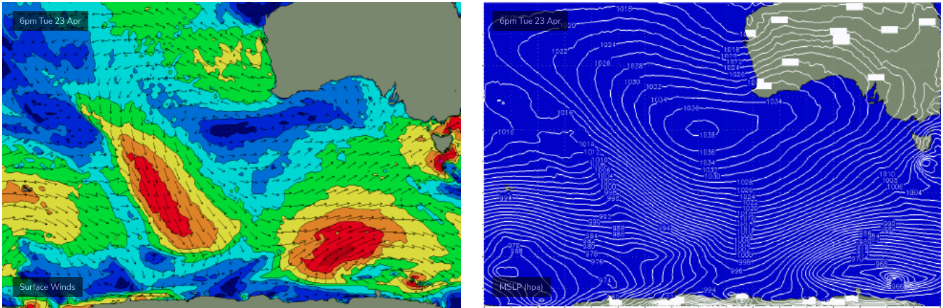
Friday has a new S/SW groundswell in store, generated by a strong polar low developing south of WA and SA on Tuesday (see below) which will deliver the best swell in this week’s sequence - for Victor Harbor. Unfortunately, the more eastern position of this development will occur inside the Mid Coast’s swell shadow, so Friday’s surf potential in the gulf will be reliant on residual energy from other sources (that being said, clean 1-2ft waves are still quite possible).
Victor Harbor looks great on Friday though with this new swell expected to produce strong 5-6ft+ surf across the coast, and even better - we’ll see a weakening of the pressure gradient as the frontal conveyer belt moves to the east, so local winds will become light and variable, creating clean conditions.
As such, Friday is well worth your time and attention down south.
This weekend (Apr 27 - 28)
Although the storm track will move out of our primary swell window later this week, strong peripheral activity will maintain plenty of surf at Victor Harbor this weekend. And, conditions should remain clean with light variable winds both days.
Friday’s strong surf will ease slowly through Saturday from 4-5ft to 3-4ft at Middleton, before levelling out at around 3ft for Sunday.
The Mid Coast won’t see much size this weekend but both days should have minor background energy allowing for small inconsistent sets for the grommets at the reefs; Saturday is the pick with the most size.
Next week (Apr 29 onwards)
Another strong series of fronts is lining up to push below the state this weekend, setting up another strong swell event for the first half of next week.
More on this in Wednesday's update.