Large clean swell tomorrow morning, good again from Thursday

South Australian Forecast by Craig Brokensha (issued Monday 25th July June)
Best Days: South Coast Tuesday until mid-afternoon, later Wednesday South Coast, Thursday onwards South Coast
Recap
Easing stormy waves from the 3ft range Saturday morning on the Mid with the wind easing late in the day offering fun options for keen surfers, smaller and 1-1.5ft Sunday morning. Later in the day though a new stormy swell kicked up with hail and strong onshore winds into the evening.
This swell has held around 3ft this morning with a stronger groundswell in the mix as winds persisted from the NW but with much less strength.
The South Coast saw an average swell with onshore winds Saturday morning, improving later in the day as some better groundswell filled in.
Sunday was better with offshore winds and a stronger groundswell offering decent options from Middleton to Waits and Parsons.
Today a larger swell has peaked in the 4-5ft range around town across the South Coast under NW offshores.
Another vigorous front is pushing in from the west and this will bring a strong mid-late afternoon W/SW change and late increase in windswell across both coasts.
This weekend and next week (Jul 23 - 29)
 As talked about last week, we've got a very active week of surf ahead.
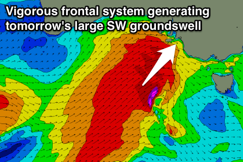
Over the weekend a vigorous polar low formed in the Heard Island region, projecting a fetch of severe-gale to storm-force W/SW winds towards us (right). This low has since taken the form of a frontal system south of WA, with a fetch of severe-gale SW winds moving in quickly from the west.
This frontal system will generate a large SW groundswell for tomorrow, peaking through the morning to 6ft+ across Middleton with larger waves at deep water offshore reefs and out at Waits. The Mid Coast is due to see 2-3ft surf.
Winds are due to improve through tomorrow as another strong front races in from the west, swinging a fresh W/NW breeze more NW through the the day ahead of a mid-late afternoon W'ly change.
This will again kick up a late increase in stormy swell across the Mid, easing back from 2-3ft Wednesday morning.
 The South Coast will see stronger long-period SW groundswell energy from the initial stages of the low, coming in larger than the short-range swell kicked up by this secondary front, with easing 5-6ft sets across Middleton and larger waves out at Waits.
Conditions will be poor though with a fresh SW'ly, improving through the day and tending W/NW into the afternoon.
Thursday looks good again as the SW groundswell continues to ease under W/NW-NW winds.
Into the end of the week and weekend good levels of reinforcing SW groundswell are due off a weaker but persistent mid-latitude frontal activity moving through our swell window. during the end of the week.
The Mid Coast should hold around 1-2ft through Friday and Saturday, fading Sunday with the South Coast seeing 3-4ft sets at Middleton into Friday afternoon and Saturday.
Winds will remain favourable for the South Coast with a NW offshore Friday and N'ly winds Saturday.
Longer term we've got some solid long-period W/SW groundswell due early next week, but more on this Wednesday.
Comments
Haven't seen sets feather out here for a long time!