Indonesia/Maldives forecast March 21

Indian Ocean Basin analysis by Craig Brokensha (issued Thursday 21st March)
This week through next (Mar 22 - 29)
An inconsistent S/SW groundswell should be peaking through today, with it due to ease slowly over the coming days.
This will be stopped by the arrival of an inconsistent, small, long-range SW groundswell that was generated in our far swell window, around the South African region. This swell is due to build slowly on Sunday, easing slowly through Monday.
We’ll then be looking at slow surf through the rest of the week. There’s a slim chance of a small pulse of S/SW swell into later Wednesday but more so Thursday generated by a late forming low to the south-west of Western Australia. Any size from this swell will be small and limited to locations from Bali, west, though not reaching the Mentawais.
We then look towards the larger, stronger swell due into the following weekend, arriving on Sunday the 31st.
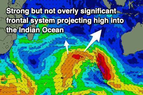
The source of this swell and backups for the following days will be a broad but not overly strong polar front projecting high up into the Indian Ocean, under the influence of the Long Wave Trough.
Initially a polar fetch of W/NW-W/SW gales will weaken while tending more S/SW in direction, pushing up to latitudes similar to Perth. This will generate a mix of swell periods with varying strengths, arriving later Saturday but peaking through Sunday, with a reinforcing pulse of S/SW groundswell for later Monday/Tuesday. I feel the models are over-forecasting the size a little but we'll review this Tuesday.
Local winds will start to shift from monsoonal westerlies to weak trades over the coming period, opening up the marquee breaks for business.
Over to the Maldives and we’ve got a good mix of new S’ly swell and background SE trade-swell with both due to ease tomorrow, further into Friday.

Come Sunday, the SE trade-swell looks to muscle up a little, along with background levels of S’ly groundswell but of greater importance is the stronger SE swell due into the middle of next week across the region.
This is being generated as the remnants of TC 18s squeezes against a strong high off Western Australia, setting up a great fetch of SE winds aimed towards us.
A moderate sized pulse of swell is due from this source, arriving through Monday but really showing through Tuesday before peaking Wednesday morning.
It should ease slowly into the end of the week, only to be replaced by the Southern Ocean swell, coming in large next weekend. More on this Tuesday.
Eastern Indonesia:.
Inconsistent S/SW groundswell today to 5ft+ across exposed breaks, easing tomorrow and further Saturday.
Small-moderate sized, inconsistent SW groundswell building to 4ft Sunday afternoon, easing from a similar size Monday morning.
Small S’ly groundswell signal late Wednesday, peaking Thursday morning for Bali and locations west.
Large mix of SW swells arriving late Saturday week, peaking Sunday to 6ft to occasionally 8ft into the afternoon, easing Monday. Secondary, reinforcing pulse of S/SW swell to 6ft+ later Monday, and Tuesday the 2nd.
Variable winds (tending locally offshore each morning) ahead of weak sea breezes. Weak SE trades kicking in from Tuesday, variable in the mornings.
Uluwatu 16-day Forecast Graph/WAMs
Western Indonesia/Mentawais/South Sumatra:
S’ly groundswell this afternoon to 3-4ft, easing into the weekend.
Small-moderate sized, inconsistent SW groundswell to 3-4ft Sunday afternoon, easing from a similar size Monday morning.
Small-moderate sized, mid-period S/SE swell building Friday, peaking on the weekend to 3-4ft across exposed breaks, easing slowly next week.
Large mix of S/SW swells building later Saturday, peaking Sunday to 6ft to occasionally 8ft across the magnets.
Variable winds tomorrow morning, tending S/SW into the afternoon, variable tending SE from Saturday onwards. Winds tending variable again later next week/weekend.
Mentawai 16-day Forecast Graph/WAMs
Maldives:
Reinforcing S’ly swell for this morning to 3-4ft across the southern atolls, easing into tomorrow and Saturday. Easing SE trade-swell also in the mix.
Inconsistent S’ly groundswell and building SE trade-swell Sunday with 3-4ft sets on the southern atolls, easing during the day and 3ft waves across other breaks.
Stronger SE swell building slowly Monday, more so Tuesday and reaching a peak Wednesday morning to 4-5ft across exposed breaks, easing slowly into the end of the week.
Large S’ly groundswell next weekend to 6ft across the southern atolls.
E-E/SE winds tomorrow, E’ly Saturday and Sunday while freshening a touch. Winds tending E/NE through Monday and Tuesday, weaker into the middle to end of the week.
Comments
Latest notes are live.
Hi Craig im going to South Africa in a few weeks has swellnet
got WAMS coverage for that area as I cant locate it. Thanks
Not at the moment EVO, but use the Ments for a bit of an idea. They don't capture the Southern Ocean to the south-west of South Africa though..
https://www.swellnet.com/reports/indonesia/sumatra/mentawai/wams
Well sounds like the trip is starting off solid. Going to interesting after a long layup with injury.
Thanks buddy got it. Exactly what I was looking for I never would of found it