XL long-period groundswell inbound

Hawaii North Shore, Micronesia and PNG forecast by Craig Brokensha (issued on Tuesday 27th November)
Best Days: North Shore keen surfers early Saturday, experienced surfers Wednesday through the end of next week - Micronesia Sunday and then Thursday through next weekend - PNG Friday next week onwards
This week and next (Nov 28 - 30)
Hawaii: The surf's been on a steady decline since Monday's XXL swell event, and we'll see it continue to drop away from 3-4ft+ early tomorrow, small to tiny into Friday.
Our new weak mid-period NW swell for Saturday is still on track, generated by a weak fetch of strong NW winds moving in from the west-northwest. This is part of a broad low with multiple embedded features, none of which are well aimed in our swell window.
 The swell should kick wave heights up to 4-6ft through Saturday and our S'ly winds due tomorrow (SW into Friday) are due to become more variable in the morning ahead of afternoon N/NE sea breezes.
The swell will ease through Sunday with stronger E/NE-NE winds, best at dawn before becoming bumpy and wind affected.
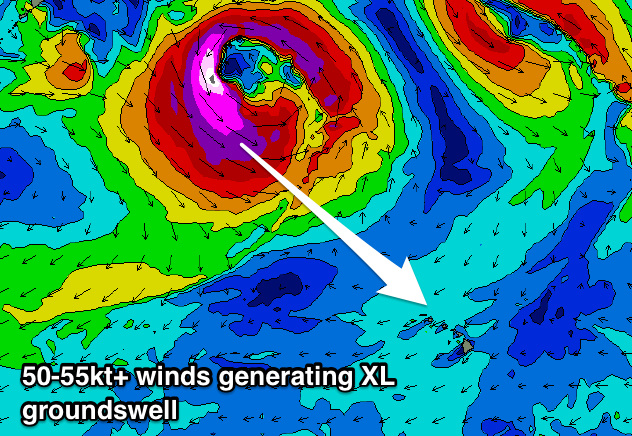
As pointed out last update, an XL swell event is on the cards for next week and it's still well on track.
There'll be a flurry of poorly aimed frontal activity south-east of the Kamchatka Peninsula ahead of it, but on Saturday afternoon and evening, a relatively weak low pushing east off Japan will deepen significantly with an injection of cold air off the Russian continent.
The low will 'bomb' resulting in a fetch of severe-gale to storm-force W/NW winds to form, projecting east-southeast towards us while maintaining strength through early next week.
Forecasts have the low retracting north to the Aleutian Islands, stalling with a secondary burst of severe-gale N/NW winds forecast to be projected through our northern swell window through until early Thursday.
 What will result is an XL long-period NW groundswell, though not to the size of Monday, with the storm not pushing as close.
We should see a late kick in size Tuesday on dark, though under an existing small NW swell, while Wednesday will see wave heights jump rapidly to 15-18ft through the day, if not for the odd bigger bomb at the peak of the swell.
This swell will ease back slowly Thursday from the 12-15ft range, smaller into Friday though still large, while a reinforcing N/NW groundswell should fill in for the start of the Billabong Pipeline Masters on Saturday, offering 6-8ft sets, easing through the day.
Winds are looking great again for the XL swell event with morning offshores and relatively weak E'ly trades into the afternoons, while next weekend we may see stronger and more troublesome E/NE trades kick in.
Longer term it looks like we'll see a temporary blocking pattern setup, but check back here on Tuesday for more details.
North Shore Forecast Graph
North Shore WAMs
Micronesia: We've got small levels of easing N'ly swell across the region and it will remain small to tiny ahead of a slight increase in N'ly energy Saturday afternoon, peaking Sunday off the broad low drifting towards WA.
We should see small 3ft+ sets under E/NE trades on Sunday, easing into early next week.
 The bombing low forming off Japan is expected to produce a large N'ly groundswell event for later next week, kicking to 6ft to possibly 8ft by dark Thursday, easing from a similar size Friday. This will be fresh and gusty but favourable E/NE trades.
As the N'ly groundswell eases some new NE trade-swell is expected to fill in, produced by a broadening and strengthening fetch of E/NE trades north-east of us during next week.
This will produce a moderate sized north-east trade-swell, for later next week and weekend to 4-6ft or so with weaker trades, but more on this Tuesday.
Palikir Pass Forecast Graph
Palikir Pass WAMs
Papua New Guinea: We should be seeing some inconsistent new N'ly groundswell building today, the same one that impacted Hawaii, reaching 2-3ft, holding a similar size tomorrow and then easing into the weekend.
We'll then see small levels of N/NE trade-swell developing early next week to 2ft to occasionally 3ft ahead of the better N/NE trade-swell due late in the week and more so next weekend.
This looks to provide the most size seen since doing these Forecaster Notes this season, with exposed breaks due to reach the 4-5ft range later Saturday and through Sunday. Winds are looking favourable at this stage and variable in the mornings ahead of NW sea breezes.
Comments
A sneak peak into the start of the waiting period for the Pipe Masters ^^^
Craig, been many years since I reviewed northern hemisphere charts for snow. But the 4 major models all show a blocking weak low around the 8-12 (as per your notes). There does appear to be a weak west-east fetch associated with the meandering low but suspecting this is good for 3ft of background energy at best?
I suppose the takeaway is we need the low to breakdown (or strengthen?) and get a model upgrade (or three)... Early days..
Hey Craig, Stu,
When do you think they'll finish sunset? Looks like they need a full day. Tuesday small. Wednesday I'm assuming too big. Last day Thursday but maybe borderline too big still?
Hopefully they they choose Thursday over tuesday.
Big enough for Eddie?