Slow start to the season

Hawaii North Shore, Micronesia and PNG forecast by Craig Brokensha (issued on Thursday 8th November)
Best Days: Swell magnets tomorrow and Fridau, Monday morning, later Tuesday through Thursday next week
This week and next (Nov 9 - 16)
Hawaii: Welcome to the first Hawaii Forecaster Notes of the 2018/2019 season.
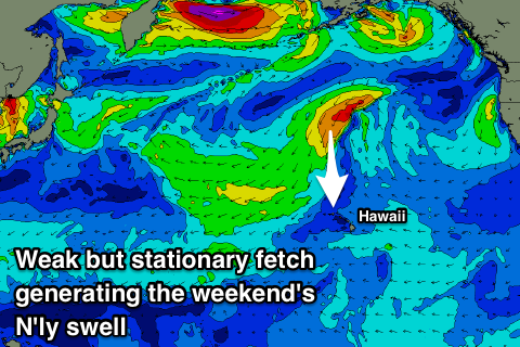
And unfortunately there's no 'typical' swell events lining up through the forecast period with a large blocking high setting up north-west of the island chain.
Typical swells are generated by lows forming off Japan or the Kamchatka Peninsula, projecting east or south-east towards Hawaii, but instead a blocking system is in place.
 We've got small surf out of the NW that will persist tomorrow to 3-4ft on the sets.
Over the coming days a surface trough is expected to squeeze the eastern flank of a strong high sitting north-west, aiming a strengthening fetch of N/NE winds through our northern swell window.
This fetch will be near stationary and as a result we'll see a moderate to large and persistent N'ly swell generated, building through Friday and peaking on the weekend Saturday/Sunday.
We should see 6ft+ sets across north swell magnets most of the weekend (smaller other breaks), easing slowly back into early next week.
 Winds will deteriorate owing to the strengthening winds to our north with E/NE trades due to swing more N/NE and strengthen through Friday, persisting all weekend out of the N/NE-NE, tending back more E/NE early next week as the swell eases.
As the trough weakens we'll see a slow moving cold front push down from the Aleutian Islands through our northern swell window, generating a fetch of strong to gale-force NW winds.
A moderate sized N/NW groundswell should be generated, building Tuesday afternoon to 4-5ft at magnets by dark, peaking Wednesday to 5-6ft and then easing slowly Thursday.
Beyond this there's nothing too significant on the cards at all with a weaker N/NW windswell due on the weekend, slower thereafter.
North Shore Forecast Graph
North Shore WAMs
Micronesia: With the lack of storm activity off Japan there are no surfable N'ly swells for the marquee reefs this forecast period and instead we'll just see pulses of NE trade-swell though to no major size.
Winds will actually go variable from Sunday through all off next week opening up the east and north-east facing breaks for business which usually get smashed by the E/NE-NE trades.
Palikir Pass Forecast Graph
Palikir Pass WAMs
Papua New Guinea: Not much in the way of surf at the moment with a tiny weak N/NE windswell, but into the middle of next week we should be seeing a touch more surfable NE trade-swell filling in, generated by a burst of E/NE-NE trades east of Hawaii later this week and through the weekend, weakening next week.
Size wise an inconsistent 2-3ft wave is due Wednesday through Friday next week on the swell magnets, easing into the weekend slowly with variable winds.
Comments
It's Hawaii time.
Forecasts for Hawaii, Micronesia and PNG.