Large swells persist until Thursday, slow next week

Hawaii North Shore, Micronesia and PNG forecast by Craig Brokensha (issued on Tuesday 16th January)
Best Days: Hawaii - Experienced surfers Tuesday through early Thursday, Micronesia - Later Thursday through Sunday, PNG - Every day over the coming period
This week and next (Jan 17 - 26)
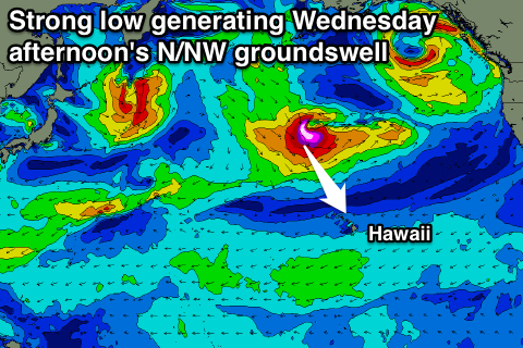
Hawaii: The weekend's XXL swell (shown above) is on the ease across the North Shore but directly north-west of us, we're set to see a very intense low forming, with a fetch of severe-gale to storm-force W/NW winds generated through our northern swell window.
We'll see the swell easing back through tomorrow from the 10ft range on the sets, smaller early Wednesday ahead of the new N/NW groundswell arriving late morning and pulsing to back to the 8-10ft range into the afternoon.
 E/NE trades will create clean conditions over the coming days, strengthening through Wednesday and persisting Thursday while tending more E'ly, then easing and swinging more E/SE into the weekend.
The swell will fade quickly through Thursday as a result of the low pushing off quickly to the east, dropping back from 6ft or so, much smaller Friday.
Longer term there's nothing too major at all due into next week as the North West Pacific Ocean falls quiet.
A couple of strong lows are expected to spawn off Japan but track north-east and stay at some distance away from us. Beyond this the region remains benign, but more on this next update.
North Shore Forecast Graph
North Shore WAMs
Micronesia: Not too much on the cards for our region besides a fun pulse of mid-period N'ly swell later Thursday through Sunday.
The source of this swell will be a weak fetch of N'ly winds on the backside of the low moving east through our swell window.
Exposed breaks to the north swell should build to 3-4ft by dark Thursday, hold Friday and Saturday before easing into Sunday under fresh E/NE trades.
Longer term we'll see small to moderate levels of E/NE trade-swell but with persistent E/NE trades, creating average conditions.
Palikir Pass Forecast Graph
Palikir Pass WAMs
Papua New Guinea: Our current run of trade-swell will ease off slowly over the coming days owing to the established fetch of E/NE trades between Micronesia and Hawaii breaking down late week.
We should still see exposed breaks picking up 3-5ft surf tomorrow through Friday, tailing off slowly from Saturday, smaller into next week and around 2-3ft. Winds look favourable with weak E/SE trades over the coming week, more variable from the weekend.