Easing N/NE swell with a good NW swell Saturday and stormy waves early next week

Hawaii North Shore forecast by Craig Brokensha (issued Thursday 2nd February)
Best Days: Hawaii / North swell friendly breaks the coming days, Saturday morning experienced surfers, Thursday next week onwards, Micronesia and PNG each day from Saturday
This week and next (Feb 3 - 10)
Hawaii: Solid N/NE groundswell today with 6ft sets at most breaks and the odd bigger one at more exposed locations.
The low that generated this swell to our north-east has now weakened and with this we'll see the swell ease over the coming days, dropping from the 6ft range at exposed breaks tomorrow morning on the sets, smaller Friday from 3-4ft.
Light E/SE offshores are due tomorrow morning ahead of sea breezes and then similar conditions Friday.
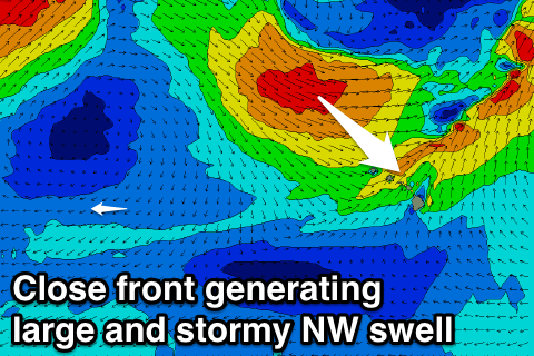
Our moderate to large NW groundswell for Saturday is still on track, with a distant but strong low spawning off Japan, now weakening while retracting back across the Kamchatka Peninsula.
We'll see inconsistent but good 6-8ft sets on the North Shore Saturday with variable tending S/SW winds, easing through Sunday from 5-6ft with freshening S/SW Kona's.
Into next week we'll see a broad low pressure system forming to our north, with a couple of embedded fronts spinning around it, bringing windy, large and onshore waves across the North Shore.
 The first front will move across us Sunday but with a SW fetch, no swell is due to be generated.
Stronger W/NW winds will move in Monday along with the first front, kicking up some poor windswell, while larger levels of mid-period NW swell are due Tuesday from a better fetch of NW gales through our swell window.
Consistent stormy 12ft+ waves are due on Tuesday across the North Shore with easing NW winds.
Conditions will be poor, but cleaner surf will be seen Wednesday as the swell eases from the 10ft range, but keep in mind it will be close spaced mid-period energy.
Thursday is looking smaller as winds revert back to the E/SE again.
Longer term, some persistent moderate to large sized W/NW groundswell is expected from a broad slow moving low to our north-west, with various fronts spinning around it, similar to early next week's setup.
We should see the surf build through the end of next week, being large from Saturday through Monday but with SW breezes, more variable from Sunday. We'll look at this closer Tuesday.
North Shore Forecast Graph
North Shore WAMs
Micronesia: Small waves are due tomorrow, with some new N/NW groundswell due Saturday and Sunday coming in at 3-4ft+ across exposed breaks.
Our larger swell for Monday is still on track, with a vigorous low pushing off Honshu, Japan due to aim a fetch of gale to severe-gale NW winds through our swell window. Sets to an easy 6ft are due most of the day, easing through Tuesday from the 5ft range.
A secondary burst of strong NW winds towards us on the tail of the low should produce a reinforcing mid-period N/NW swell for Wednesday back to 3-4ft+ across exposed breaks, easing slowly Thursday.
More N/NW groundswell is due into later next week and weekend from another strong low off Japan, with the size coming in around 4-5ft, but more on this Tuesday. E/NE trades are expected for the most part through the period, creating great conditions on the protected reefs.
Palikir Pass Forecast Graph
Palikir Pass WAMs
Papua New Guinea: The focus off this forecast period is N'ly groundswell pulses across exposed breaks.
The first for Sunday should reach 3ft into the afternoon, hold Monday before the bigger increase on Tuesday to 4ft and then tailing off slowly through Wednesday, slowed by a reinforcing increase to 3ft Thursday.
Longer term the weekend should see a renewal of N'ly groundswell but more on this Tuesday.
Light winds are expected for the most part, a little from the west Monday and Tuesday. But more on this Tuesday.