XL swell building tomorrow, peaking early Wednesday, large swells to follow

Hawaii North Shore forecast by Craig Brokensha (issued Tuesday 24th January)
Do you want to receive these forecasts to your inbox regularly and go into the chance to win a trip for you and a mate to P-Pass? You’ve only got one more week to sign-up and enter, so click here.
Best Days: Hawaii - Experienced surfers Tuesday through Thursday, Friday, Saturday morning experienced surfers, Tuesday experienced surfers, Micronesia and PNG every day over the coming week and a half
This week and next (Jan 25 - Feb 3)
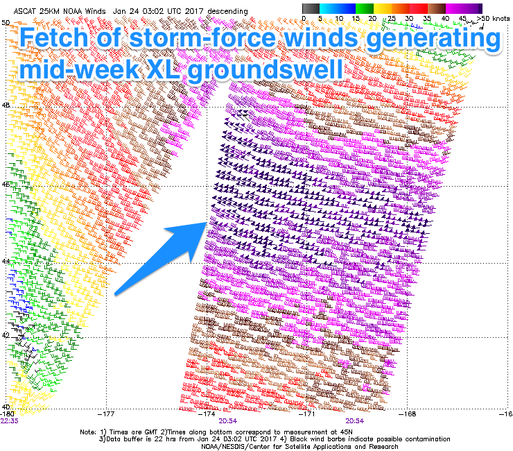
Hawaii: We're at a low point in swell activity across the North Shore, but into tomorrow an XL NW groundswell is due to build strongly through the day, peaking Wednesday before easing off from Thursday.
The source of this swell is a vigorous low spawning off Japan, strengthening and widening in scope to our north-west the last few days while generating a fetch of severe-gale to storm-force W/NW winds.
The swell should arrive through tomorrow morning, building to an easy 10-12ft by later in the day, if not bigger on dark, peaking Wednesday morning with 12ft+ sets.
 Only a slight drop in size is expected into the afternoon, down more noticeably from the 8-10ft range Thursday morning.
Conditions are looking excellent with freshening E/NE trades tomorrow, strong Wednesday and easing back again Thursday.
Into Friday a small to moderate sized mid-period NW swell should fill in, building to 5-6ft into the afternoon, ahead of a new large swell Saturday and then XL increase Monday.
Saturday's swell looks to be over-forecast in my opinion with the fetch generating it being not overly strong and also patchy with various bursts of W/NW gales from off of Japan, closer towards us due through the end of the week.
The swell from these fetches should show later Friday but a peak is due Saturday morning to 10-12ft, easing off later in the afternoon.
Variable winds are due most of the day, with onshore NW winds Sunday.
Of greater significance is a larger swell for Monday, produced by a strong and closer moving storm down towards us over the weekend. A fetch of gale to severe-gale NW winds will be projected towards Hawaii, generating a consistent XL groundswell for Monday in excess of 15ft.
Because the storm will push so close though winds will be poor and from the N/NE tending NE, with E/NE trades on Tuesday as the swell eases from a more N'ly direction.
Longer term there's nothing too significant on the cards, but more on this Thursday.
North Shore Forecast Graph
North Shore WAMs
Micronesia: It's been non-stop across the region with large pulses of N/NW groundswell and another is due this afternoon, kicking to 4-6ft at exposed north facing breaks, easing off slowly from a similar size tomorrow morning.
A more pronounced easing trend is due Thursday and E/NE trades will persist through the period and early next week before going variable Tuesday.
Our reinforcing N/NW groundswell for Friday (the one impacting Hawaii) should offer similar sized sets to 4-6ft across north facing breaks, easing through the day and further Saturday.
 One final pulse of small swell is due Saturday afternoon and Sunday morning but only to 3ft to maybe 4ft.
Moderate amounts of E/NE trade-swell are due across exposed breaks through the coming days, easing off into Friday and Saturday morning ahead of a good pulse into Sunday and early next week before easing as the trades weaken mid-week.
Exposed breaks look to come in at 3-4ft Tuesday morning, with those lighter winds opening up some fun windows, similar Wednesday.
Palikir Pass Forecast Graph
Palikir Pass WAMs
Papua New Guinea: The fun mix of NE trade-swell and N'ly groundswell will continue through the coming days. Inconsistent 3ft sets out of the north are due from tomorrow afternoon through early next week, ebbing and pulsing with each reinforcing swell.
The NE trade-swell is expected to be more consistent and coming in 3-4ft+ from tomorrow through the weekend, kicking a little Tuesday and Wednesday before easing from Thursday.