Poor surf tomorrow, improving with size and energy Friday with workable options, clean and easing into the weekend. Stormy swell on the cards for next week.
Primary tabs
/reports/forecaster-notes/eastern-tasmania/2023/12/20/good-windy-swell-building-late-week-great
Craig
Wednesday, 20 December 2023
/reports/forecaster-notes/eastern-tasmania/2023/12/18/dynamic-period-generally-weak-swell-producers
Craig
Monday, 18 December 2023
We've got a dynamic period ahead with deepening troughs/lows in the Tasman Sea but swell wise nothing significant is due.
/reports/forecaster-notes/eastern-tasmania/2023/12/15/small-nne-swell-followed-sse-next-week
Craig
Friday, 15 December 2023
A flat weekend with average N/NE followed by S/SE swells next week.
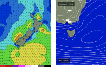
/reports/forecaster-notes/eastern-tasmania/2023/12/13/nothing-much-work-period
Craig
Wednesday, 13 December 2023
I hope you made the most of the recent S'ly swell, with small surf due into the end of the week, tiny thereafter.
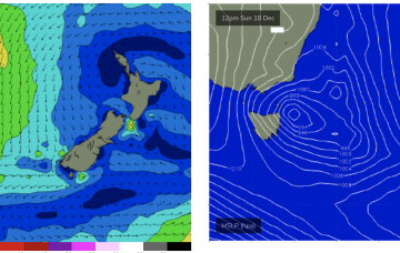
/reports/forecaster-notes/eastern-tasmania/2023/12/11/make-the-most-tomorrow
Craig
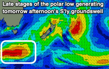
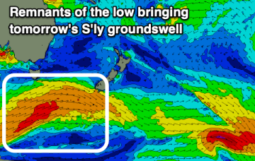
Monday, 11 December 2023
A good S'ly groundswell is due with favourable winds.
/reports/forecaster-notes/eastern-tasmania/2023/12/08/workable-ne-swells-sat-some-sly-groundswell
freeride76
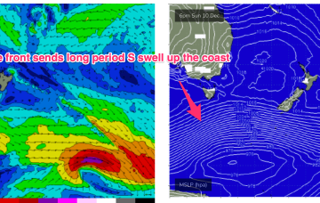
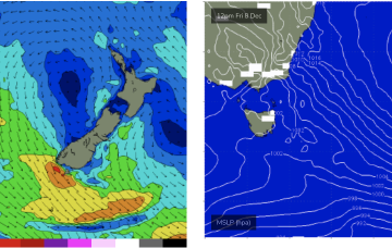
Friday, 8 December 2023
A powerful front and parent low passing under the continent and lower Tasman Sun into Mon looks to supply long period S’ly groundswell.
/reports/forecaster-notes/eastern-tasmania/2023/12/06/few-workable-options-over-the-weekend
freeride76
Wednesday, 6 December 2023
The troughy pattern we’ve seen since early November continues, with surf potential continuing to favor small swells from infeeds into the trough.
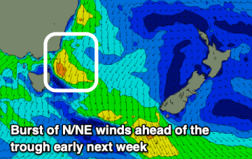
/reports/forecaster-notes/eastern-tasmania/2023/12/04/remaining-small-and-weak-week
freeride76
Monday, 4 December 2023
No major swells expected this week. The headline feature is a potential major tropical cyclone drifting into the Coral Sea with a poleward (southwards) track late this week, over the weekend and into next week. It’s unlikely for the system to reach far enough south to generate surf for NETas but there are some modelled outcomes suggesting it might.
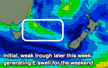
/reports/forecaster-notes/eastern-tasmania/2023/12/01/solid-easing-swells-over-the-weekend-not-much
freeride76
Friday, 1 December 2023
No great change to the weekend f/cast. Low pressure has moved off the coast and is slow moving, with a broad fetch of strong E’ly winds on the southern flank of the low supplying plenty of E’ly swell to NE Tasmania.
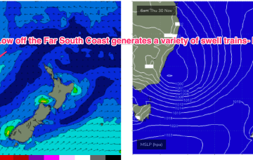
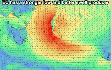
/reports/forecaster-notes/eastern-tasmania/2023/11/29/large-and-stormy-e-swells-ahoy-low-moves-far
freeride76
Wednesday, 29 November 2023
A dynamic weather event is underway as a complex inland low approaches the Far South Coast of NSW, expected to enter the Tasman Sea tomorrow. A moist NE-E/NE infeed into the low is generating plenty of rain (heaviest falls on the South Coast) and building swells from the same direction, focussed on NETas. We’ll see large surf develop across NETas as the low moves offshore tomorrow.