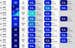
A small short range southerly swell may materialise at south facing beaches in Northern NSW on Friday in the wake of this system, but we’re not going to see much more than a foot or two tops. And SE Qld won’t see much, if anything from this source - possible a tiny level of residual trade swell in the water but that’s about it.
Primary tabs
/reports/forecaster-notes/south-east-queensland-northern-new-south-wales/2014/05/28/small-small-small
thermalben
Wednesday, 28 May 2014
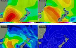
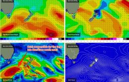
/reports/forecaster-notes/south-east-queensland-northern-new-south-wales/2014/05/26/solid-south-swell
thermalben
Monday, 26 May 2014
We should see a healthy percentage of this size fill into exposed south facing beaches along the Northern NSW coast on Tuesday
/reports/forecaster-notes/south-east-queensland-northern-new-south-wales/2014/05/23/good-weekend
thermalben
Friday, 23 May 2014
We’ve got some fun waves on tap for the weekend. The current east swell is a little different from many ‘groundswell’ events, in that we’re seeing a gradual increase in size and period (today’s a little bigger than yesterday, and tomorrow should hopefully be a smidge bigger than today).
/reports/forecaster-notes/south-east-queensland-northern-new-south-wales/2014/05/21/incoming-east
thermalben
Wednesday, 21 May 2014
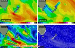
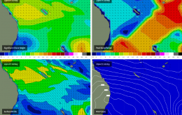
Looking good for the rest of the week. A new east swell is expected to slowly build across the coast duringThursday, generated by a tidy low pressure system located mid-way between New Zealand and Samoa over the last few days.
/reports/forecaster-notes/south-east-queensland-northern-new-south-wales/2014/05/19/fun-east-swell
thermalben
Monday, 19 May 2014
We’ve got a fairly linear surf forecast ahead for the next few days. Essentially, the trade swell that peaked over the weekend is expected to slowly ease from Tuesday through Wednesday and into Thursday morning.
/reports/forecaster-notes/south-east-queensland-northern-new-south-wales/2014/05/16/weekend-o-trade
thermalben
Friday, 16 May 2014
There’s only one major surf focus for the weekend and that’s a building trade swell that’ll peak in size later Saturday or early Sunday, although the overall trend will be slow so there should be much of a difference either side.
/reports/forecaster-notes/south-east-queensland-northern-new-south-wales/2014/05/14/great-weekend
thermalben
Wednesday, 14 May 2014
Tradeswell is the main focus of the weekend, which is good because it’ll offer a wide range of surf possibilities across SE Qld.
/reports/forecaster-notes/south-east-queensland-northern-new-south-wales/2014/05/12/all-eyes-weekend
thermalben
Monday, 12 May 2014
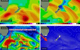
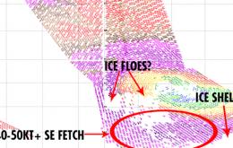
The reason this is worth noting is that the storm force SE fetch mentioned above lies across and to the south-east of this possible ‘giant ice floe’, meaning that the resulting swell generated by this SE fetch would probably become heavily attenuated by it.
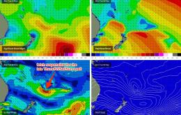
/reports/forecaster-notes/south-east-queensland-northern-new-south-wales/2014/05/09/fun-weekend
thermalben
Friday, 9 May 2014
Southeast Queensland and Northern New South Wales Surf Forecast by Ben Matson (issued Friday 9th May)
Best Days: Sat: decent S/SE swell in Northern NSW with good winds across the Mid North Coast (probably OK early morning in the Far North, and also in SE Qld - but it'll be much smaller north of the border). Sun: steadily easing swell with good winds in most regions.
/reports/forecaster-notes/south-east-queensland-northern-new-south-wales/2014/05/07/incoming-south
thermalben
Wednesday, 7 May 2014
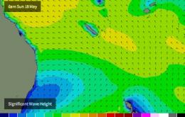
Right now we’re seeing an increase in mainly short range S’ly swell, but some mid-range energy has already reached the Mid North Coast and will fill in across remaining regions overnight, generated by a strong fetch that entered the southern Tasman Sea yesterday.