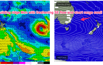
The resulting high pressure ridge is leading to deep onshore flows and a trough along the coast is expected to move offshore Sun and form a broad trough of low pressure early next week.
Primary tabs
/reports/forecaster-notes/south-east-queensland-northern-new-south-wales/2024/05/08/conditions
freeride76
Wednesday, 8 May 2024
/reports/forecaster-notes/south-east-queensland-northern-new-south-wales/2024/05/06/strong-se-surge
freeride76
Monday, 6 May 2024
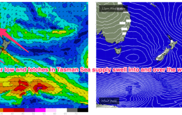
In fact, it becomes reinforced by a new high and this peanut high straddling Tasmania will hold a firm ridge along most of the Eastern Seaboard with another working week of SE winds, gradually backing off into the weekend. A stalled trough looks to linger off the coast bringing plenty of unstable weather and possibly windows of lighter winds
/reports/forecaster-notes/south-east-queensland-northern-new-south-wales/2024/05/03/few-windows
freeride76
Friday, 3 May 2024
Monster high pressure has barely budged since Wed, maintaining a S-SE flow right up the Eastern Seaboard, with a coastal trough ensuring plenty of unstable, rainy weather.
/reports/forecaster-notes/south-east-queensland-northern-new-south-wales/2024/05/01/another-round-fun
freeride76
Wednesday, 1 May 2024
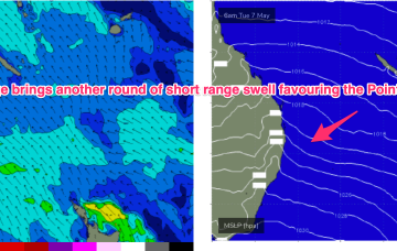
With a widespread E-SE wind field in the Tasman at a minimum we’ll see moderate amounts of E/SE-E swell through the first half of next week with another round of fun surf on the Points.

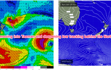
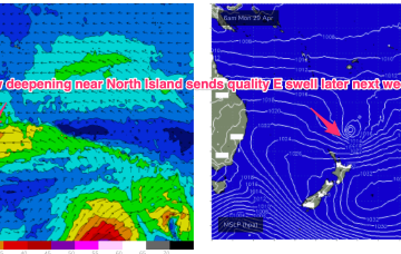
/reports/forecaster-notes/south-east-queensland-northern-new-south-wales/2024/04/29/another-se-surge
freeride76
Monday, 29 April 2024
A trough of low pressure NE of the North Island is deepening today but moving southwards at a clip through the swell window with reduced swell potential compared to Fridays notes.
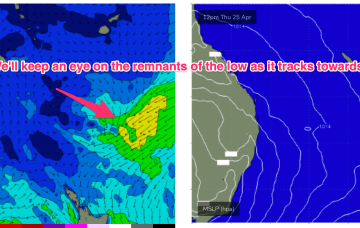
/reports/forecaster-notes/south-east-queensland-northern-new-south-wales/2024/04/26/fun-sized-e-swell
freeride76
Friday, 26 April 2024
At issue is a trough in advance of a major high pressure ridge. At a minimum, the trough will charge up a SE surge along the NSW coast with an increase in S/SE-SE swell later Tues and into Wed
/reports/forecaster-notes/south-east-queensland-northern-new-south-wales/2024/04/24/generally-easing
freeride76
Wednesday, 24 April 2024
A weakening trough of low pressure near New Caledonia is seeing easing E swells across the sub-tropics.
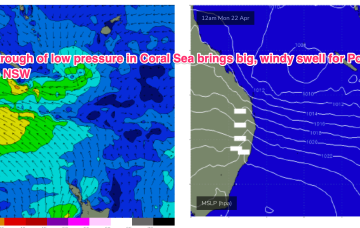
/reports/forecaster-notes/south-east-queensland-northern-new-south-wales/2024/04/22/size-downgrade
freeride76
Monday, 22 April 2024
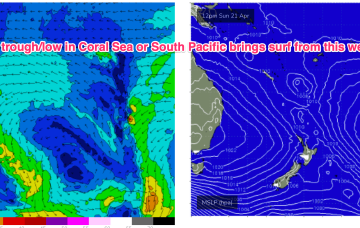
We’ve got a dominant (1035hPa) high pressure cell sitting just north of the Victorian border, bringing settled conditions and light winds to Central/Southern NSW and strong but easing SE winds in the sub-tropics where a trough of low pressure in the Coral Sea is currently active but dissipating and moving East.

/reports/forecaster-notes/south-east-queensland-northern-new-south-wales/2024/04/19/extended-pumping
freeride76
Friday, 19 April 2024
By Mon morning we should have a complex trough of low pressure NE of K’gari (Fraser Is) with a well developed fetch of strong SE winds feeding into the low and extending well out into the Coral Sea.
/reports/forecaster-notes/south-east-queensland-northern-new-south-wales/2024/04/17/clean-mornings
freeride76
Wednesday, 17 April 2024
The gist of it is a trough line in the Coral Sea, which may deepen into a low pressure system and drift towards the North Island (GFS scenario) or move towards the QLD coast as a coastal trough and intensify a NE infeed into the SEQLD, then NSW Coast possibly as early as Tues.