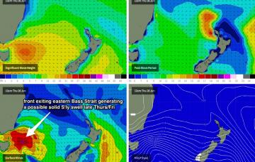
We’ve got a windy period ahead for the entire SE region of Australia in conjunction with a major cold outbreak. In fact, apart from a temporary easing trend later this week (sometime around Thurs), a renewal of strong fronts will bring about further windy conditions from Friday right thru’ the weekend.
Primary tabs
/reports/forecaster-notes/sydney-hunter-illawarra/2014/06/23/cold-and-windy-flukey-south-swells
thermalben
Monday, 23 June 2014
/reports/forecaster-notes/sydney-hunter-illawarra/2014/06/20/small-flukey-south-swells-tap
thermalben
Friday, 20 June 2014
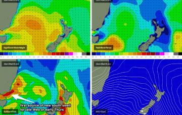
During Saturday afternoon, a new pulse of small, long period S/SE groundswell is expected to reach the South Coast, generated by a small polar low that developed right on the tail end of the frontal passage that is responsible for the current south swell.
/reports/forecaster-notes/sydney-hunter-illawarra/2014/06/18/lots-small-southerly-swells-inbound
thermalben
Wednesday, 18 June 2014
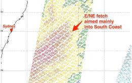
A series of strong fronts have been powering through the lower Tasman Sea over the last day or two and although not very well aligned for the East Coast, are generating a series of southerly groundswells that’ll impact the region for the short term.

/reports/forecaster-notes/sydney-hunter-illawarra/2014/06/16/plenty-swell-south
thermalben
Monday, 16 June 2014
So, the synoptic situation is as such: the Tasman Low responsible for our current swell is tracking towards New Zealand post-haste, and its swell source has long been shut off inside our swell window. So a rapid easing trend is expected into tomorrow.

/reports/forecaster-notes/sydney-hunter-illawarra/2014/06/13/easing-east-then-building-south
thermalben
Friday, 13 June 2014
The new E/SE swell currently building across the region will peak overnight and trend downwards steadily through Saturday.
/reports/forecaster-notes/sydney-hunter-illawarra/2014/06/11/great-waves-most-days
thermalben
Wednesday, 11 June 2014
Looking like a good finish to the week.
/reports/forecaster-notes/sydney-hunter-illawarra/2014/06/09/excellent-waves-expected-later-week
thermalben
Monday, 9 June 2014
A complex, deep trough currently lies off the west coast of New Zealand, and it's expected to be an active source of swell for the entire NSW coastline for the rest of the forecast period.
/reports/forecaster-notes/sydney-hunter-illawarra/2014/06/06/windy-weekend-waves-great-surf-longer
thermalben
Friday, 6 June 2014
The current building short range south swell should hang around into Saturday morning, before easing a little throughout the day. Of more interest is the likelihood that local winds will throttle back after lunch, and possibly swing to the SW during the afternoon, courtesy of a small low forming east of Bass Strait, deep within a broad trough stretching right along the East Coast.
/reports/forecaster-notes/sydney-hunter-illawarra/2014/06/04/average-short-term-still-potential
thermalben
Wednesday, 4 June 2014
Nothing major to finish the week. A broad, stationary high in the Bight is directing a moderate southerly wind across southern NSW and it’ll keep a lid on quality for the coming days.
/reports/forecaster-notes/sydney-hunter-illawarra/2014/06/02/easing-surf-week-becoming-explosive-next
thermalben
Monday, 2 June 2014
Mainly small surf for the rest of the week, originating from a couple of sources. However, whilst still quite some time away, there are several indicators suggesting that we could be on target for the first East Coast Low of the season early next week.