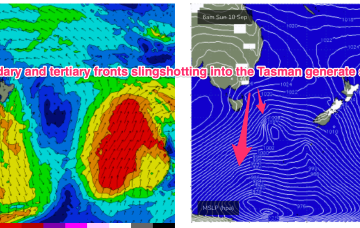
A front and small low are now racing across the Tasman with a high over NSW moving into the Tasman and directing a freshening N’ly flow across most of the Eastern Seaboard. So far, so spring. A complex low, front and trough then approaches from the W, bringing a flush of W’ly winds and a S swell.
Primary tabs
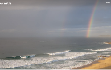
/reports/forecaster-notes/sydney-hunter-illawarra/2023/09/06/good-options-end-the-week-plenty-sizey-s
freeride76
Wednesday, 6 September 2023
/reports/forecaster-notes/sydney-hunter-illawarra/2023/09/04/few-options-work-week-potential-s-swells
freeride76
Monday, 4 September 2023
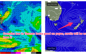
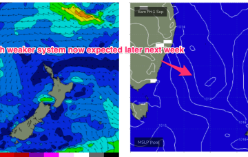
The following system expected over the weekend now looks a little stronger and under current modelling is expected to be a source of fun sizey S swell, potentially with several large pulses into next week.

/reports/forecaster-notes/sydney-hunter-illawarra/2023/08/31/winter-goes-out-whimper-quiet-start
freeride76
Friday, 1 September 2023
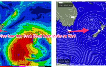
No great change to the weekend f/cast. S swells will be the dominant force in the water through tomorrow, mostly mid period stuff whipped up by a proximate fetch of S-SSW winds generated by a front and trough of low pressure forming in the Tasman.

/reports/forecaster-notes/sydney-hunter-illawarra/2023/08/30/low-in-the-tasman-start-spring-another
freeride76
Wednesday, 30 August 2023
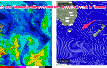
There’s a troughy pattern in play at present, with a long trough snaking from inland QLD down to the Central/Southern NSW Coast. Return flow off the back of a retreating high is feeding N’ly winds into the trough line. We’re expecting a front to interact with the trough overnight Thurs to form a low pressure trough in the Tasman.
/reports/forecaster-notes/sydney-hunter-illawarra/2023/08/28/low-pressure-in-the-tasman-kick-spring
freeride76
Monday, 28 August 2023
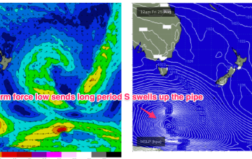
A trough will extend along the East coast before a front through the latter half of the week brings vigorous S’ly winds by Fri. The trough is expected to move offshore and merge with a more tropical derived depression to form a large trough of low pressure in the Tasman over the weekend. This has been a feature of synoptic prognostic charts for a few weeks now, with forecasts generally tending to weaken and fall apart as the event unfolds. Lets hope this one comes to fruition to deliver some chunky S-SE swell.
/reports/forecaster-notes/sydney-hunter-illawarra/2023/08/25/long-period-s-swells-keep-coming
freeride76
Friday, 25 August 2023
We’ve still got the basic building blocks in place that we mentioned on Wed with the proviso that everything looks a little weaker and disjointed. High pressure moves NE of Tasmania and the troughs remain inland, although we may see a weaker trough area move off the North Coast of NSW early in the week.
/reports/forecaster-notes/sydney-hunter-illawarra/2023/08/23/small-flukey-swells-the-weekend
freeride76
Wednesday, 23 August 2023
A cold front and long trough are bringing a S’ly change to the NSW coast, extending into the sub-tropics later today and overnight. There’s not a great deal of useful swell generating winds associated with the change so only modest short range S swells are expected to accompany it.
/reports/forecaster-notes/sydney-hunter-illawarra/2023/08/21/quiet-week-ahead-potential-unruly
freeride76
Monday, 21 August 2023
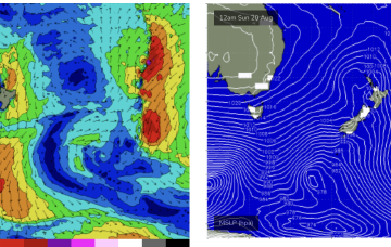
The remnants of the weekends frontal systems have set up a fading off axis fetch near New Zealand with the current run of small S swells also on the way out. A weak mid week front will bring a wind change and a small flush of S swell but next week looks a bit more robust although with plenty of winds.
/reports/forecaster-notes/sydney-hunter-illawarra/2023/08/18/workable-s-swells-over-the-weekend
freeride76
Friday, 18 August 2023
Minor tweaks to the weekend f/cast with the front and associated low just looking a little more organised and not so disjointed. It’s not going to add much materially to wave heights, we’re still looking at pulsey S swell to 3-4ft through Sat with a mid/late morning peak offering up some bigger 3-5ft surf at S facing beaches.
/reports/forecaster-notes/sydney-hunter-illawarra/2023/08/16/non-punchy-south-swell-the-weekend
thermalben
Wednesday, 16 August 2023
Easing swells are expected for the rest of the week.