Stormageddon - video

From Catalyst:
In the first week of June, four states were battered by a ferocious east coast low unusual in its size, damaging storm surge and intense rainfalls. Tasmania was under a deluge as an unprecedented seven rivers broke their banks in torrential downpours. Huge seas and an unusual wave direction carved out huge sections of waterfront properties and flooded low lying areas. Did warmer temperatures play a role? How are storm patterns changing across Australia and will we see more like this?
Comments
Interesting. I would like to see the evidence for the last claim.......that storms transport sand towards the coast from further offshore. Inshore it is clearly not true.
Storms are fascinating and get all the news but I reckon it's the more subtle environmental changes that are the ones we have to watch out for and they could have more far reaching impacts.
Disappearing kelp forest off WA...any fishos from WA notice that one?
http://www.abc.net.au/news/2016-07-08/kelp-forests-of-the-sea-in-wa-slas...
Mass mangrove die off in the Gulf of Carpentaria, far away from most human influences.
http://www.abc.net.au/news/2016-07-10/unprecedented-10000-hectares-of-ma...
Did you hear the one about a fossil seeker stumbling upon a pristine beach holding the balance of our future in palm of his hand ? (spoiler) All comes down to a simple grain of sand ! Seems Earth's future depends upon one's next step? This episode hits home, most astute and considerate for sharing 'swellnet'! Follow up with.... Catalyst -5/4/2016 'Tassie Fires' (Is cost too high to keep'world heritage status' for World's oldest forest?)... weds this episode perfectly,verifying increased storm intensity trending southward,adding too that cost is truly devastating. Lucky country,too good to be true? Mother Earth Father Time....
thx good suggestion... the Tassie report is disquieting
very interesting..thanks for posting guys! the validity of the sand sampling analysis seemed shaky at best
Look up Optical Stimulated Luminescence (OSL) dating on Google scholar. its actually very accurate.
late reply - cool technology I wish these docos would go into more detail about this type of technology but I guess the avg punter isn't interested. Seems a bit like carbon dating? Found good research to back it up and it seems sound but I'm surprised given the dynamic nature of beaches that it is so accurate and precise
its only precise until the last time it was buried, once exposed the clock resets. this means that you cant take a sample anywhere it needs to be targeted and in context. this limits sampling to undeveloped sand dunes up and down the coast. I agree would have loved to see another half an hour on this subject not 15 mins
Going back to the sand transport issue. If the amount of sand along the Collaroy/South Narrabeen stretch has not changed, which seems to be the claim, then there are a few anomalies. Not least being the very significant amounts of sand that have been dredged from the lagoon and deposited there over the last few decades. If the total is the same then there has been significant erosion. And on that note, they have just announced they will soon be dredging the lagoon again and trucking the sand south.
I was reading this,
"The Collaroy/Narrabeen Beach and Fishermans Beach embayment is essentially a closed sediment compartment, which means that significant quantities of sand do not enter or leave the region.
Although sand does not enter or leave the compartment, sand redistributes within the embayment (eg generally offshore in storms and onshore in calmer periods, or from offshore into Narrabeen Lagoon, or mechanically from the Lagoon entrance on to Collaroy/Narrabeen Beach). The effects of seawall construction in closed sediment compartments such as Collaroy?Narrabeen Beach and Fishermans Beach are not comparable to effects at other locations such as the Gold Coast and Noosa where there are strong net longshore transport of sand and no closed sediment compartment."
http://yoursaywarringah.com.au/czmp-narrabeen-beach/faqs
Thanks wally so if we stopped transporting sand the southern end would be greatly and permanently depleted. A point no-one involved seems keen to acknowledge.
You may be right, but not necessarily. The sand that is 'mechanically' moved from the lagoon may move out and south 'naturally' but more slowly without intervention. It's a well-studied stretch of coast so someone should be able to provide an informed answer.
I haven't had time to do the necessary research on this but I would be very surprised if, in recent decades, there was not a very significant net south to north movement. How else can you explain the repeated large scale trucking of sand south and the continued build up of sand at the lagoon entrance?
Here is the data. I have had a look and am still thinking about it.
http://www.nature.com/articles/sdata201624#background-amp-summary
good reading!
Thanks heaps for this. Looking at their data, I can't see the sth > nth movement of sand you've observed. I'm not saying it's not in there, but that my untrained eye can't spot it if it is. I looked mostly at Fig 2 in relation to Fig 1. But some thoughts on interpreting an increase in nth-end sand and a corresponding decrease in sth-end sand if you spot that. First, the trucking of sand isn't evidence of any long term trend, just of human intervention which could be based on any number of factors, unfortunately good science rarely among them. Second, it could be that sth-end sand moves east when nth-end sand moves west and vice versa (kind of see-saw like), rather than sand moving sth > north or vice versa.
Or the sand could be getting pushed north as you say, which commonsensically seems likely given the prevailing S swells. Thanks again for the link - great stuff.
Thanks Jacko. One of the issues is that the data does not seem to make any mention of the trucking of sand south. I might have missed it but surely it should be somewhere upfront even if the quantities moved are insignificant compared to natural transport. There is no doubt that sand moves in and out of the lagoon by various methods. The bank at Nth Narrabeen probably depends on the regular deposition of sand from the lagoon to some extent. Sand that is trucked away potentially depletes the sand available for this process.
The residents whose properties were damaged are now campaigning for the public funding of a sea wall. Many seem not to have realised that "actions of the sea" are a standard insurance exclusion and are facing large repair bills and significant devaluation of their properties if the wall is not built.
They might have an argument in terms of the wall and their properties acting as a defence of Pittwater Rd and associated infra structure but this is far from clear. Allowing for a one metre sea level rise, even if storms do not intensify, it would seem that some form of coastal defence will have to be constructed as there is no viable alternative route through that area.
I don't think the lagoon is necessarily a big factor, though they think that historically the lagoon was mostly closed to the sea. So I guess, without the tidal inflow, mostly when the lagoon is closed, not much further sand would be being deposited into it.
They reckon that there is seasonal movement back and forth between north and south on that Narrabeen/Collaroy stretch. With winter south swell pushing sand north and then summer easterly swell pushing sand back south. The southern end tending to be widest in May and narrowest in November.
In the link you provided, they say that the northern end is a dissipative beach (energy being dissipated on the offshore banks and a longer flatter run up the beach), and the southern end is a reflective beach (wave energy being reflected back out to sea). Reflective beaches are classics for high sand loss during big seas. You would have to think the more intrusive development onto the foredune there has made the southern end more reflective.
thanks fr the info / explanation, wally.
bb, there is currently a video on 'another surf website' about the recent black nor easter swell. in that, there is a guy talking about errosion / sand movement on that stretch and what can/should be done re those properties. worth a look if u haven't seen it, and not just for that either. would be curious to find out if the amount of sand trucked south is significant in the bigger scheme of things or not, as u ask.
i wish it was possible to do something about the closeouts on that stretch. without screwing everything up of course
Gotta love Anja - pretty hot ! - some more government incentives for rainwater tanks across the states could help mitigate floods in the urban areas. They would work in a retention of storm water volume hitting the streets all at once and give the councils stormwater infrastructure a chance to get the water away.
Homeowner would have to use the water regularly , perhaps on vege garden , so tank isn't always full !
The big picture with sand is that it is the third most used natural resource behind air and water. Construction uses massive quantities, and desert sand is not generally suitable. They reckon 200 tons of sand are needed just to build a medium-sized house. 1km of highway uses 30,000 tons of sand. Plus, for example, just think of all the glass in the world. Sand wars have occurred and might escalate.
Here's how they do it in Sierra Leone. Find a beach and put it on the back of trucks.
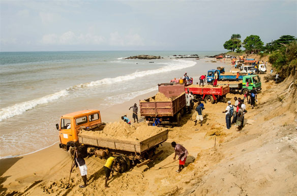
yeah. i heard a canadian journalist interviewed on the abc recently - writing a book on sand. check this out
http://www.wired.com/2015/03/illegal-sand-mining/
Thanks also ojackojacko, Distracted and yes... all contributors here. After storm clean-up ..(FF )> this column with Swellnet's permission to 27/6/2016..(Scientists expect sand flow on East Coast to slow)...continues on from here examining central & northern sands and the BIG turnaround.We Queenslanders lived lives with sand mining on World Heritage Island and protected Moreton Bay islands.Only for next lives to forever struggle to keep world status as Great Sandy conveyor belt turns to arc surfing reserves traversing NSW marine reserves.If all these presented Swellnet study pieces playout alongside fellow commentators dire observations,best take stock of obvious fallout.(Tip) to our NSW cousins World Heritage proposals set to increase with enshrined EPA sound export sand mining(coastal management) complete with Sandpumprimed pointbreaks. Ring a bell ! Hooroo!
oops!.. 27 July 2016 (Scientists expect sand flow on east coast to slow'.).Anyway it's another 'swellnet classic' must read..Nice photo there wally! I know what evil swellnet mastermind villains are thinking !Just enough truckloads to shape that Mini- Me right hand pointbreak .How many tons we need to stoke it up wally?
For concise Qld Eastcoast Low chronology .... (Known impacts of east coast lows,1846-2009 - Harden up) by Mr Jeff Callaghan,retired Senior Severe Weather Forecaster,Bureau of Meteorology Brisbane. Thanks Swellnet.