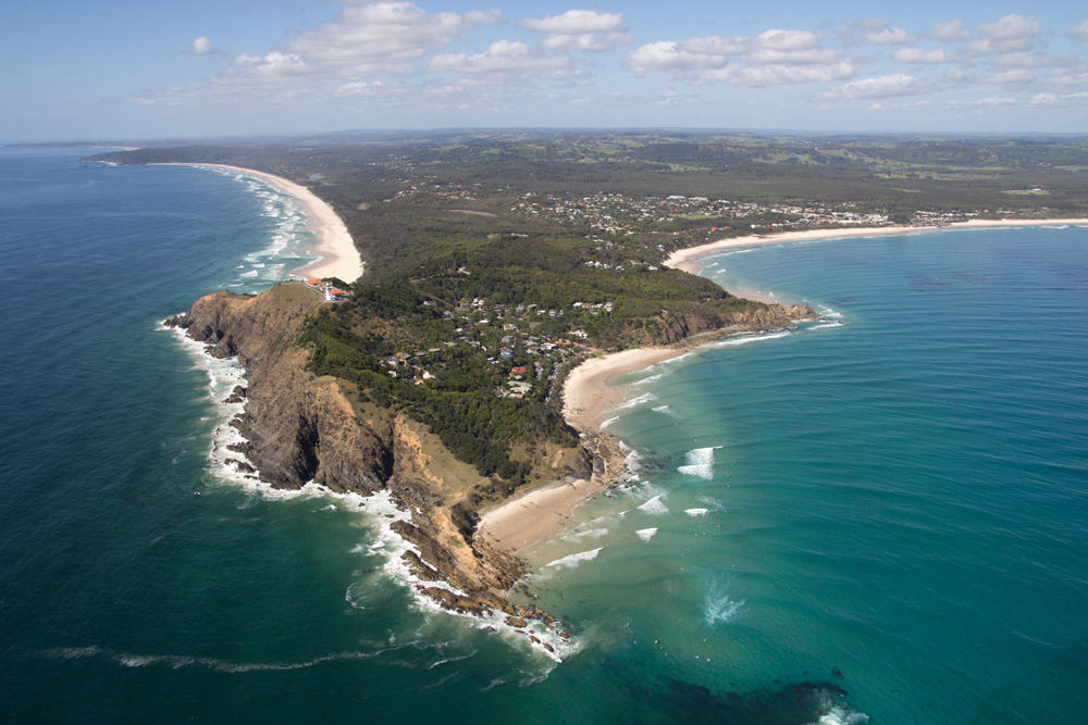
Scientists expect sand flow on East Coast to slow

The northern New South Wales and southern Queensland coasts are noted for their righthand pointbreaks. Each point is peculiar in its own way working on various tides and swell directions, yet they all have a common currency – sand. From roughly the mid-point of the NSW coast, sand begins its journey north. It's transported in the nearshore zone, rounding headlands during big swells and coming to rest in the lee side of each outcrop. The configuration of the deposited sand determines the shape of the waves breaking above it.
Approximately 500,000 cubic metres of sand passes the NSW/QLD border each year ultimately ending up just north of Fraser Island, where the flow of sand drops into a deepwater abyss. Recently, scientists have predicted the northward flow of sand will reduce over the coming century. Reduced sand flow will have wide ranging effects, not the least being an adverse effect on those beloved sandbottom pointbreaks.
Ian Goodwin is a surfer from Sydney's northern beaches and is also an Associate Professor in Climate and Coastal Risk at Macquarie University. Last week, Goodwin, along with research partners Thomas Mortlock and Stuart Browning, had a paper published in the Journal of Geophysical Research that surmised sand flow on the East Coast will reduce throughout the 21st century due to changes in storm wave events.
Their theory is built upon an observed poleward expansion of the tropics, a pattern they understand will continue in the coming years. On Australia's East Coast 'tropical expansion' will see the tropics move south by 2.5º which will in turn alter the types of swells that impact the coast and ultimately effect the northward flow of sand.
In their study the scientists separated large swell events on the East Coast into eight categories. Then using historical data – that being 40 years worth of buoy information plus storm tracks - they determined the characteristics for each type of swell event, such as how they approach the coast, how wave power is apportioned, and how each type of system transports nearshore sand deposits.
Using future climate change projections, Goodwin and his research partners observed how the regularity of each of the eight storm systems would change given tropical expansion. They found storms that form in the tropics would become more common, while storms that form in the southern reaches of the Tasman Sea would become less regular. In short, there'd be more north-east swells and less south swells. The net result being an anticlockwise shift in the mean wave field with waves approaching the coast closer to perpendicular. It is this shift that will effect sand transport.
What needs to be understood is that large swell events are the drivers for sand 'connectivity' - when sand moves beyond a closed embayment and begins its journey north. Unsurprisingly, Goodwin and his partners found that southerly swells currently dominate the coast. These southerly swell events drive the sand north. Yet southerly swells will reduce in frequency, and less swell from the south means less sand moving north. The flow on effect will see the coastline reshaped.
In the southern and central regions of the NSW coast, sand that would otherwise move north will increasingly stay put. While in the north of NSW and the Queensland coast up to Fraser Island, the quantity of sand moving north in the nearshore zone will reduce. In effect, the conveyor belt of sand that we've all come to rely on will begin transporting less and less cargo.
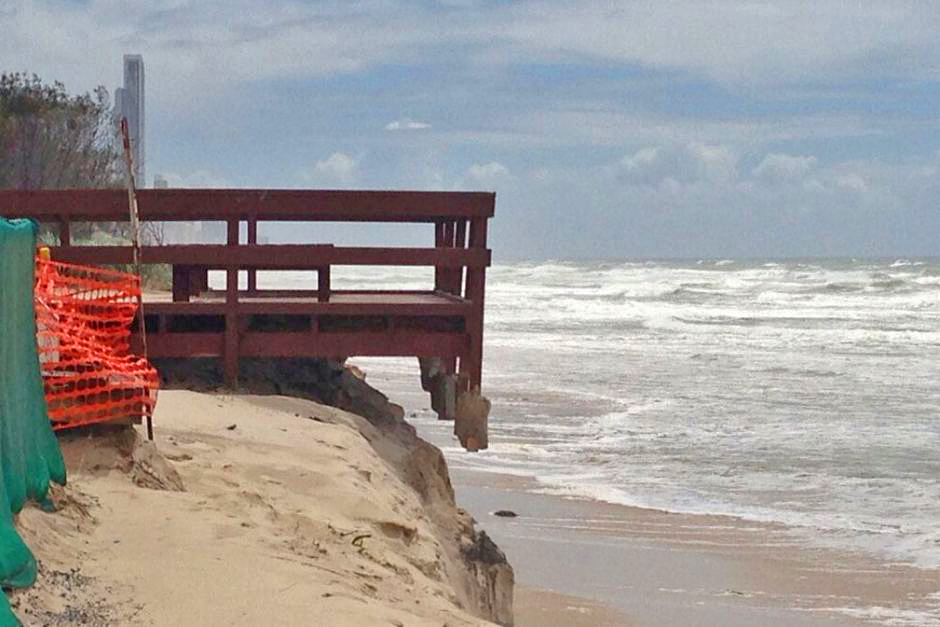
Less available sand is something coastal stakeholders will need to seriously consider. Coastal councils, for instance, will need to take extra caution as Goodwin predicts that more E/NE swells will erode the southern ends of beaches - as was seen during the 'Black Nor-Easter' swell of early June - and less sand will be available to provide a natural fix to storm damage.
While for surfers the effects are obvious: less sand around the northern side of headlands means deeper water, more holes, and correspondingly a more uneven wave shape. In fact, this study indicates powerful waves breaking over shallow sand and running off for a hundred metres or more will become less common as the underlying spit formation becomes infrequent. So what's Ian Goodwin's advice to north coast surfers? "Get out there now!"
Comments
Bugger! I cannot conceive any current wave that will benefit from this. Time will tell however the back of the envelope calculation suggests a number of world class waves will be downgraded to fair to good - but there are no scenarios where average waves become world class = net loss!
Kirra?
Assuming the tweed pumping continues.
Funny...I can think of lots of places south of sydney that work better when cleared of sand, all of them reefs or sand over reef set ups, but only two north of Sydney. Kirra and Cudgen.
And the powers that be will continue to throw good money after bad on the border
under this scenario will sand islands such as fraser, moreton, and straddie disappear?
Well we've got a version of that scenario happening now, almost 2 months after the June black nor-easter and we've still got a major sand deficit at most pointbreaks here. Thats despite a regime of mostly small/moderate south swell episodes.
Some world class or very good waves are simply non-existent, let alone fair to good. Extend that situation out through time and it becomes a depressing one.
If sea levels are rising won't there be a slight counter effect of additional sand from erosion added to the mix?
And with sea waters rising in temperature won't there be more cyclones going further south but still north enough to produce NE swells?
Gee Free, depressing , sand movement , it's just nature doing her thing , what will really get you depressed is the rising sea levels when , todays high tides will become , the new low tides over the next couple of decades!
Hey Free, I reckon you start planning more trips to Cloudbreak, not just the big swells but even the medium ones when chicks would surf it as well.
What if you took Andrew Pitts sand slug idea and built two in a 'V' shape with the point of the "V' facing east and the area created by the 'V' a catchment for sand that gets pulled out of the nearshore zone.
Make the "V' out of concrete terapods with the 'V' starting out beyond the wave breaking zone at a depth of say 5 metres ( the top of the 'V' would be 5 metres below sea level the whole way out to the point of the 'V').
In effect creating a surf break and an underwater sand storage dam.
Good, I like north east swells better
Like sands through the hour glass, these are the days of our lives?
I just returned from Lombok where we were surfing wet season waves in the middle of the dry season!! Also free dived @ the Gilli Screens(near Desert pnt) where the coral bleaching was between 80 to 40% on the reefs! Climate change is in full bloom& progressing rapidly, we have more to worry about than if ur local sand flows to create your perfect pnt break!!ocean acidification combined with higher temps & rising oceans are all impacting upon our way of life. As humans we have faced every challenge that has challenged humanity in one way or another & managed to survive. History shows that civilisations rise to a climax & then decline, to be replaced in another form that adjusts to the situation @ the time. Our main problem is that population is rising to an unstainable level which has created the current problems we now face! If humanity is to survive a major adjustment in population is needed, this is just around the corner!!!!
So let's clear the air on Oz eastcoast ? Cyclones spin clockwise,Ocean Currents spin counterclockwise(mostly) and our surf once clockwise is 'trending' counterclockwise because less frequent more damaging storms are tracking south as climate warms. Top end down-mangroves die off drying out World heritage' Slightly Damp Tropics' starve off World Heritage ' It's Still A Pretty Good Barrier Reef' left exposed by World Heritage 'Fastest Shrinking Smallest Sand Island' now just a speck of sand in The Great Channel Straits off World Heritage 'Moreton Desert' stealing more sand from World Jetski Reserves along Bland Coast. Seems Joh was a visionary just took the rest of us a little longer to acquire that delicate Dean Bro's touch.So in the end we weather the storms,white shoes get their coastline back and the worst of it we send over the border brew'n into some gigantic mental monster thingy,I'd say your average Queenslander Queenslander call that a win win lock in another one.
So I take it you're being cynical truebluebasher?
Right you are to ask Halfscousehalf...! Wish i could laugh yes! As most local scenarios are playing out faster than our smartest can ponder.National Parks maps show once heat rises .. 3*... annihilation of Qld environment within our lifetimes.Problem is they were printed before we go into our 15th month of record heat,meaning maps are now toilet paper.Right now World is discussing about recinding World Heritage Status of earths largest living wonder.. just one more coal shipment THEY SAY! Our World listed forests as reef and Sand Islands are delicate ecosystems easily vanish quick as you like once funding drops NO TAG NO MONEY NO TOURISTS NO NOTHIN. Yes the Mangroves are near dead,a big 1/3 of reef is near dead .Here at home the GCCC rockwall races along, soon our golden beach be northward running black slurry down below the steep steps,no longer bump into turtles but be bowled over by coppers logs and yes that is happening right now. So Sad ! Perhaps your right.. one ought not joke about our foreseeable demise. I'm sorry World. I guess Journal of Geophysical Research tipped me over the edge.
Big thanks for Associate Professor Ian Goodwin presenting again for Gold Coast beach-goers..Link....(Gold Coast Bulletin August 6,2016 Gold Coast at threat of severe erosion and property damage, research shows.) or try (Golden sand Major threat facing Coast beaches) Our very GC response..."Thanks for the fish,but we got this ..heads down, back to bricking up Pacific Ocean". On behalf of Gold Coast beach-goers our apologies Mr Goodwin,Mr Mortlock and Mr Browning have a nice stay. We're ever indebted for your highly valued contributions. Hooroo!
Very important to have our souls in order.
#1 Surf Journo Stu has outdone himself with Surfing's Secret Spot.
31st Aug 2016 ...(Stu's East Coast Flow won over surfers & fellow journos!)
Qld Courier Mail salutes #1 Surf Journo with a dedication piece! Good Stuff!
"Why Sunshine Coast beaches will lose their sand to NSW."
https://www.couriermail.com.au/news/queensland/sunshine-coast/why-sunshi...
Point Cartwright was exampled...But Why? No SLSQ Beach / No Houses nor a go to Surf Hang?
For some bizarre reason the Media focused on 2013 > 2015 { Near Map } aerial snaps!
Was our fav Journo set up & exploited as a ring in poster boy for a new Map service? (Any Royalties!)
Just wot on Earth has #1 Surf Journo stirred up this time...Qldurr tbb is at a loss!
Had absolutely no right to follow this up as it would surely lead to a dead end...so you'd think?
Ok! From here the Secret Spot gets unearthed a little more...but wotz it all about.
22nd May 2017 Courier Mail have another crack at this secret spot with surfers in tow?
"Extreme Caution : Major Warning issued for Boaties!"
Well worth a look ...plenty of Surf photos & Vid & Breakwall Plans...it's all happening.
https://www.couriermail.com.au/news/queensland/sunshine-coast/extreme-ca...
Maritime Safety Qld report surfers riding 0.3m depth in Moooloolah River Mouth
Trawlers unwilling to touch it! ( Ok! So now we got Stu's Sand Flow blocking the Mouth! Got it!)
Again! Why push on as locals say Govt won't dredge the bar. The end of the matter! (Surely...Nope!)
From here we'll do a hop, skip'n'jump to this week's Surfrider Foundation asking WTF.
Proposed Eastern Breakwall Extension.
https://www.facebook.com/surfridersunshinecoast/photos/a.195385965803907...
Perhaps Stu stood on a butterfly and got ahead of himself?
Bonus! Think our #1 Journo doesn't have a secret double life! Check out Stu's next level Surf Safari!
The Best or Nothing Surf Journo moonlights for Mercedes-Benz.
https://www.mercedes-benz.com.au/passengercars/experience/mercedes-me-ma...